Exploring the Living Shoreline

in East Boston

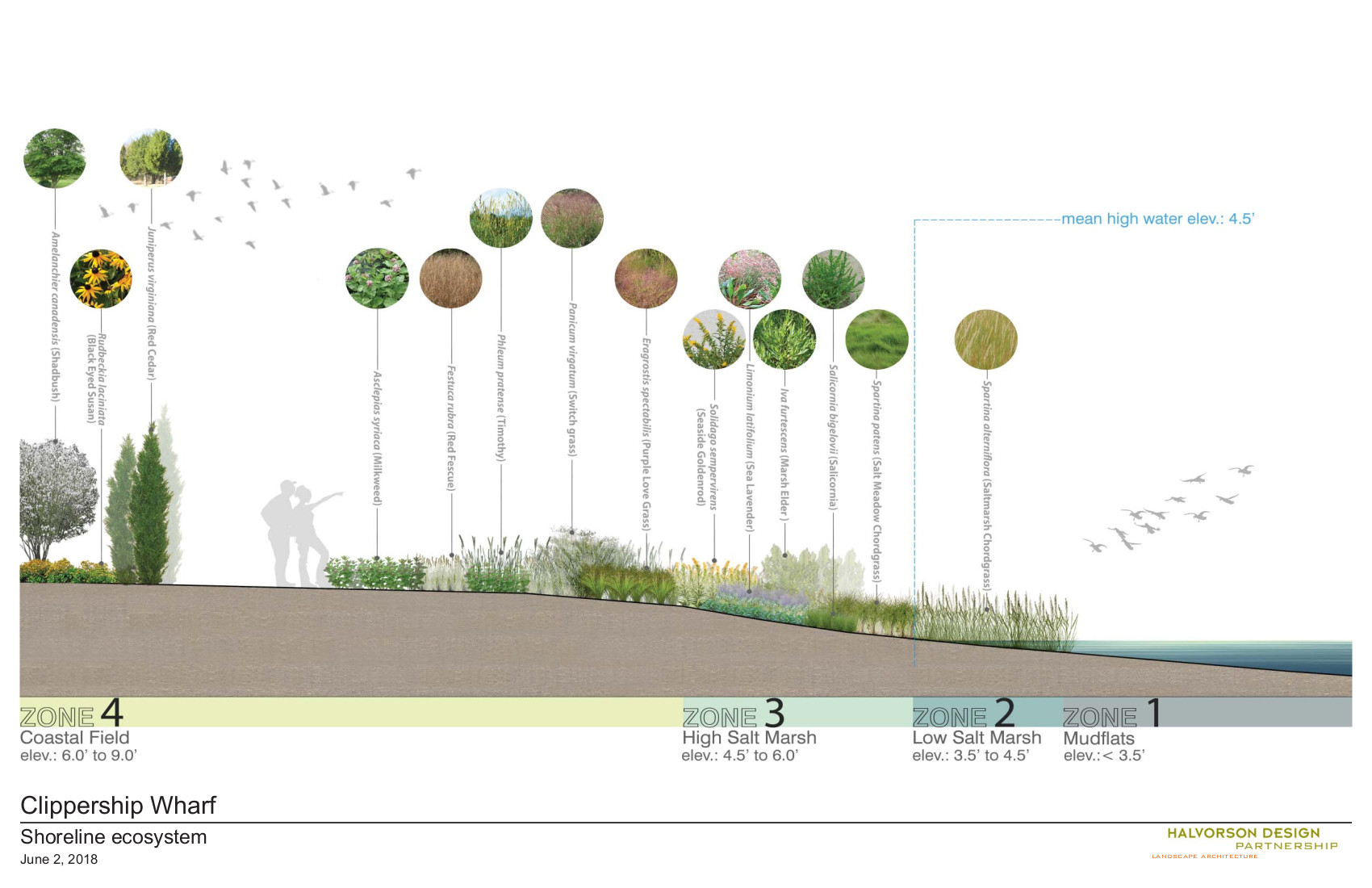
Saltmarsh chordgrass (Spartina alterniflora) and saltmeadow cordgrass (Spartina patens) were the original plant species introduced into the low and high marsh. Many additional plants now call the Living Shoreline home. How many can you identify?

Much of Boston’s shoreline between high and low tide—the intertidal zone—was lost during the 19th century, when the city was the second largest port in the country. Sea trade, ship building, and related industries dominated and changed the waterfront to fit their needs. Living shorelines recreate the intertidal zone. This one is the first such project along Boston’s Harborwalk and an alternative solution to shorelines in urban areas.

The project design transformed approximately 24,000 square feet into the new, diverse wetland community you see in front of you. Portions of the shoreline were terraced to create flat areas at different elevations. Each terrace attracts specific plants, depending on how much time they need to spend under water as the tide flows in and out. A greater diversity of plants lives on the upper terraces.

Below the marsh grasses, various animals thrive in the tide pools. Common periwinkles, blue mussels, sea urchins, northern moon snails, and sea stars feed and take shelter in the vegetation. Sea birds, in turn, feast on the animals living in the grasses. Together they create a vibrant ecosystem.

1775 map of mudflat salt marsh

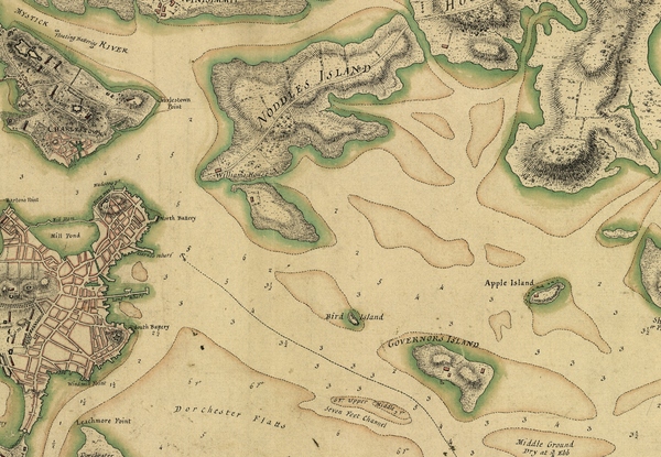
As the 1775 map shows, a mudflat-salt marsh environment once edged all of what is now East Boston.

Detail from Sir Thomas Page map. Courtesy of Norman Leventhal Map Center at Boston Public Library

Great Blue Heron

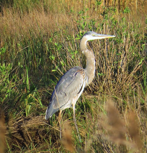
Wading birds, like the Great Blue Heron, thrive on creatures that live in shallow waters.

Photo by Trish Pastuszak

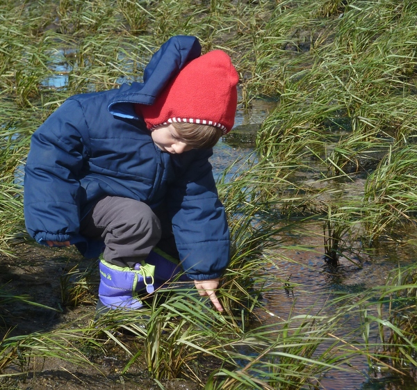
The recreated salt marsh allows you to experience the original New England coastline ecology in an urban area and witness how our shoreline grows and recedes twice a day with the rise and fall of the tide.

Photo by Liz Nelson Weaver

Sign Location

More …

A salt marsh is a coastal ecosystem that lies between open salt water and land and is regularly flooded by tides. Salt marsh can stretch hundreds of acres along the shore and is a highly productive habitat where large amounts of organic matter is deposited and decomposes, creating a food chain that sustains birds and animals.

https://www.nps.gov/subjects/oceans/salt-marshes.htm

https://oceanservice.noaa.gov/facts/saltmarsh.html

Salt marsh plays a vital role in the aquatic food web, delivering nutrients to coastal waters. It provides refuge and is a food source for animals and birds. Also, many marine fish use the salt marsh as their “nursery” for newly hatched fish before they swim into open water. Finally, people have somewhat belatedly realized that acres of salt marsh serve as important protection from ocean storms. Recognizing the extraordinary importance of salt marsh in our ecosystem, many organizations are working very hard to protect all remaining salt marsh from development.

http://www.mass.gov/envir/massbays/bhha_saltmarsh.htm

This is a vertical datum point used by developers and surveyors working in Boston. Established before the North American Vertical Datum of 1988 (NAVD’88)*, which is used nation-wide, it gives an agreed-upon baseline for below- and above-ground projects in the city.

For more information:

https://dgtassociates.com/a-flood-of-data-understanding-the-true-sea-level-in-boston/ (“Which sea level” paragraph)

https://www.mass.gov/service-details/north-american-vertical-datum-of-1988-navd-88

For tide information based on NAVD’88: https://tidesandcurrents.noaa.gov/datums.html?id=8443970

*Boston City Base, like that of many older towns and cities, precedes both the NAVD’88 and the National Geodetic Vertical Datum of 1929.

Community activists. Colonial law. Political will. New state regulations. The combination created the 43-mile Boston Harborwalk–a public path, stretching from Logan Airport through seven neighborhoods to the Neponset River. In 1978, the Massachusetts Office of Coastal Zone Management (CZM) sought to improve public access to the waterfront. They succeeded by integrating early Colonial laws into new state regulations.

In the decades that followed, community activists, city and state government, and developers of shoreline projects have worked together to ensure the Harborwalk is always constructed along the waterfront. Some sites also provide public amenities–bathrooms, meeting places, kayak launches,
etc. The result is a fabulous path welcoming residents and visitors to our vibrant clean harbor.

Early Colonial laws established public right of access along tidelands to protect citizens’ rights to fish, hunt, and navigate at sea and along the shorefront. These laws go back even further: They stem from Roman law, which was incorporated into English law and brought over to Massachusetts by English
settlers. Then, in the 1640s, Massachusetts Bay Colony passed laws permitting private docks in the intertidal area (between low and high tide) as long as public access was retained. Almost all of Boston’s waterfront is filled land that was once the intertidal area. This, together with the centuries-old legal right of access, served as the underpinnings for the 1978 CZM regulations.

Resources

No resources at this time.

Acknowledgments

  • Translation and recording thanks to the generosity of the Boston Marine Society
  • Our gratitude to the Perkins School for the Blind and David W. Cook for their partnership in creating the audio files.