Ancestral Land
in Charlestown

Joshua Winer’s mural depicts Massachusett women and men engaged in seasonal encampment activities during the pre-Colonial era.
With permission of artist Joshua Winer
The First People lived in this region for thousands of years. Their descendants, the Massachusett, named what we now call Charlestown, Mishawum— “Great Springs.” They gathered here and at other harbor locations seasonally, to farm and hunt for food.
The English purchased Mishawum from the principle sac’hem, the “Queen of the Massachusett.” They renamed the peninsula and built homes around City Square. But this part of Charlestown remained as farm land until 1801, when the federal government bought it to establish the Charlestown Navy Yard. The Navy soon filled mudflats and marsh, making land for wharves and ship building. In the 1830s, seawalls were constructed along the outer edges of the mudflats. This marked the end of made land in this section of the Navy Yard; the seawall remains in place today, to your right.
The land, however, would undergo yet another transformation after the Navy Yard closed in 1974. In the decades since, housing has sprung up along the waterfront, where the Massachusett people once fished, harvested shellfish, and launched canoes.
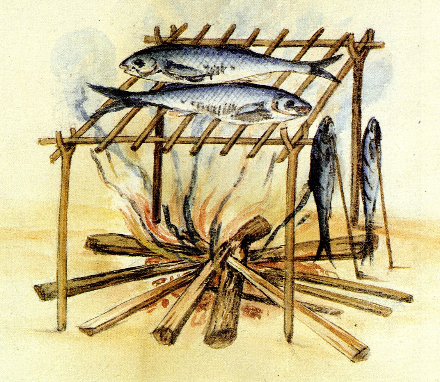
Like other coastal tribes, the Massachusett people both farmed and thrived on abundant marine resources in the estuary where fresh river water mixed with ocean water.
1585 illustration by John White of Native Americans living in present-day North Carolina. Published by Theodor de Bry in Americae pars decima.
July 17, 1605: “We anchored near an island where we observed many smokes along the shore…. There is a great deal of land cleared up and planted with Indian corn. The country is very pleasant and agreeable, and there is no lack of fine trees. The canoes of those who live there are made of a single piece, and are very liable to turn over if one is not skillful in managing them.”
From Voyage of Samuel de Champlain, 1604-1608, the French explorer’s journal. De Champlain is believed to have anchored between what is now Charlestown, a peninsula at the time, and East Boston, which was an island.
The Queen of Massachusett, principle sac’hem over all northern Massachusett bands, lived for a time in a small Indian village located in the area that is now Bunker Hill Community College.
Charlestown peninsula, detail from Sir Thomas Hyde Page map, 1775. Courtesy of Norman Leventhal Map and Education Center at Boston Public Library
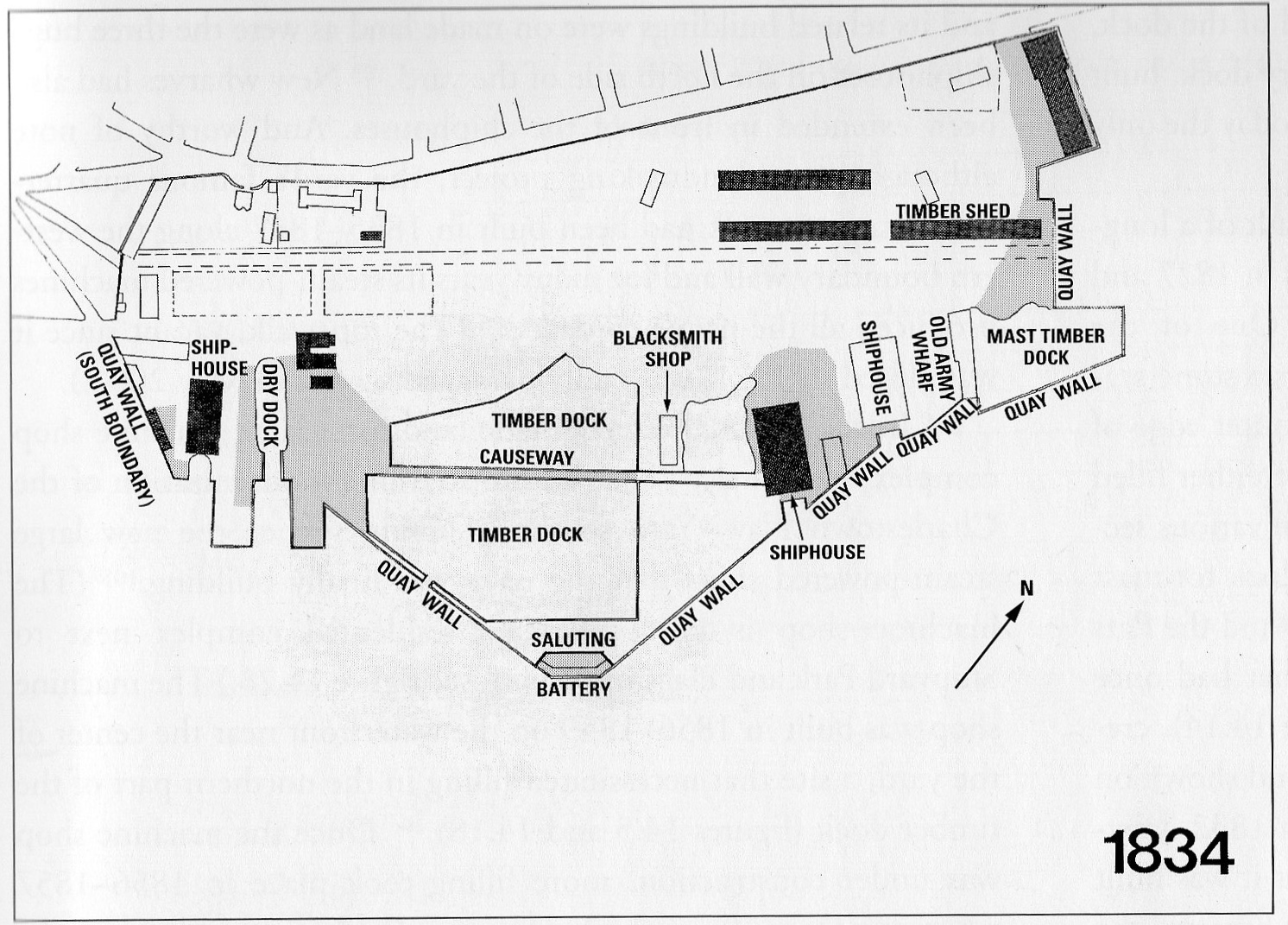
Reconstructed plan of the Charlestown Navy Yard in 1834 shows new sea walls (“quay walls” on plan). Shaded areas indicate land made between 1823 and 1834.
From Gaining Ground: A History of Landmaking in Boston. Courtesy of author Nancy S. Seasholes
Sign Location

More…
Oral tradition, archaeological evidence, and early explorers’ writing provide evidence that the confederation of indigenous Massachusett lived and thrived for centuries in what is now called the Commonwealth of Massachusetts, including the Boston Harbor watershed. Led by their sac’hems, they built homes, practiced their religion, raised families and prospered. They worked their quarries, created tools, and sculpted weapons. Several examples of small, temporary camps, dating back 2,000–3,000 years have been found near the mouth of the Charles River. Along the coast and on offshore islands, Native people planted crops, hunted, and fished. Shell middens discovered on Boston’s inner harbor islands point to intense shellfish collecting and processing. The outer harbor islands were used for fishing and seabird hunting.
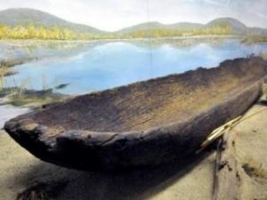
The mishoon, or dugout canoe, discovered in Weymouth in 1965, dates back to the mid 1400s. It is likely that very similar mishoons were made and used by Native Americans living along the Boston Harbor’s shore.
Photo courtesy of Weymouth Historic Commission
Where were the Massachusett people when English colonists landed in what is now Charlestown in 1630?
In the early 1600s, Massachusett tribes living in coastal villages had increasing contact with European fishermen and traders. With that came exposure to diseases to which they had little immunity. Thousands died as a result of epidemics between 1616 and 1619. Massachusett Medicine Sac’hem Ren Green writes: “Societies were disrupted, trade threatened, and defenses against rival tribes to the north were reduced due to the loss of large numbers of warriors. It was a time of great grief among the Massachusett people.”
In 1630, in what is now Charlestown, a Massachusett band lived in a small village in wetus—summer huts built and owned by the tribe’s women. The village also included an English-style thatched house, presumably from an early English settler. The Massachusett were led by a woman called the “Queen of Massachusett.” Her real name was not recorded by the English, who purchased a large part of Charlestown from her for 36 shillings. It is possible that she considered the payment as “tribute,” giving the English consent to occupy the land. The sale of land, explains Ms. Green, “was an unheard-of concept for the indigenous Massachusett.”
sources: “Cultural Landscape Report for Charlestown Navy Yard” NPS, Boston 2005.
Highway to the Past: The Archaeology of Boston’s Big Dig, essay by Brona Simon, 2001; p., and “The History of the Neponset Band of the Indigenous Massachusetts Tribe,” by Ren Green
Tragically, her true name was not recorded; the English called her Squaw Sac’hem or Queen of the Massachusett. After her husband Grand Sac’hem Nanapashemet was killed in 1619, she was chosen as the leader of the Northern Massachusett, whose territory stretched from the Piscataqua River (in Portmouth, NH) to the Charles River. She served as sac’hem until her sons came of age. She signed deeds and other legal records on behalf of her people with a stylized bow and arrow. Brona Simon writes in Highway to the Past, that though Squaw Sac’hem sold a large part of what is now Charlestown to the English, she managed to hold onto much of her people’s remaining territory longer than most of her contemporary male sac’hems. She appears to have been respected by the English officials, who responded favorably to her petitions and complaints. She was one of the last Native people to submit to conversion to English Protestant religion, and in her later years, moved to the Christian Indian town of Natick.
source: Highway to the Past: The Archaeology of Boston’s Big Dig, essay by Brona Simon, 2001.
The Pequot War (1636-38) and King’s Philip’s War (1675-78) were the result of the deep dislocation felt by many. Both wars were costly to colonists and Indian tribes, but especially so to the latter. Thousands died in battle or from injuries, sickness, or starvation. Hundreds were enslaved and sold to sugar plantation owners in the Caribbean, where they labored under brutal conditions. Some joined other tribes as captives or tribal members. Others fled west and north. A few returned or moved to the handful of remaining Christian Indian Towns in the area, like Natick and Ponkapoag (now Canton). The social cohesiveness of entire groups of indigenous people was in peril.[Source: Salisbury, Neal. Indians of New England. Indiana University Press, 1982; p. xii]
Scholar Neal Salisbury writes that between 1800 and 1945, small, often “impoverished communities of Indians struggled to retain their identities and traditions in the face of an American society with very different cultural priorities.” [p. 51] Despite enormous pressures, groups of Massachusett, Mashpee, Narraganset, Mohegan, Nipmuc, and other people managed to sustain distinctive features of their Native American identities into the 20th century and beyond. The history of New England Indians, Salisbury writes, is “marked by enormous upheavals and tragedy, but it also reveals underlying elements of continuity and triumph. For, however transformed, today’s Indians are the biological, cultural, and political descendants of peoples who began settling the region 12,000 years ago.” [p. 60]
Source: Salisbury, Neal. Indians of New England. Indiana University Press, 1982; pp 51, 53, & 60.
“We are still here,” writes Ren Green, Medicine Sac’hem of the Massachusett. “Against all odds, we have survived as a people. Ritual dance, drum, rattle, song, and rites of passage all enable the present day Massachusett tribe to transfer knowledge of our ancestors to succeeding generations. We have an oral tradition of storytelling, just as our ancestors did, that passes on the Massachusett view of how the world works, our relationship with all of nature, and why things are the way they are. There are medicine ways thousands of year old that we still practice today. We thank our ancestors for keeping the traditions, for their foresight and the gifts they left us.”
To ensure the authenticity of his murals, Joshua Winer worked closely with the contemporary Native American community, as well as Cambridge artist Ross Miller. Mr. Winer invited members of the Massachusett Ponkapoag tribe to pose for the portraits in his studio in Westwood MA. The plantings in the middle of the female figure group are corn, beans, and squash—“the Three Sisters.”
Mr. Winer’s original mural is one of two sited opposite each other on the walls of the Brooks Street underpass, in Brighton MA. The 18-foot high and 44-foot long mural was painted in 2003, as part of a neighborhood beautification initiative sponsored by Alston Brighton Community Development. While the mural depicts members of the Massachusett tribe working along the Charles River in Watertown, the seasonal villages there as well as the fishing and farming activities would have been the same as in villages closer to the mouth of the river and along Boston Harbor.
Ross Miller, with whom Mr. Winer collaborated, creates an annual work of public art on Boston Common in which participants build a fish weir together as a way to commemorate the weirs Native people once built to trap alewife in the Charles River basin. Evidence of those fish weirs, dating back more than 5,000 years, were discovered during 20th-century excavation work on Boylston Street.
For more about Joshua Winer’s art http://www.joshuawiner.com/
Resources
For an excellent overview of Native American history in the Boston area:
http://www.sec.state.ma.us/mhc/mhcarchexhibitsonline/massachusettsbay.htm
For an overview of archaeological finds from the Big Dig project:
https://www.sec.state.ma.us/mhc/mhcpdf/Big_Dig_book.pdf
For more information on Boston’s fish weir
http://www.theshawmutproject.org/BoylstonFishweir
“Archaeological Data Recovery, Town Dock Prehistoric Site [report],” Ducan Ritchie, Principal Investigator, The Public Archaeology Laboratory, Inc. Oct. 1994.
Bragdon, Kathleen. Native People of Southern New England, 1500-1650. University of Oklahoma Press, 1996.
“Cultural Landscape Report for Charlestown Navy Yard” National Park Service, Boston 2005.
Green, Ren. “The History of the Neponset Band of the Indigenous Massachusett Tribe,” and “The Northeastern Massachusett,” 2016.
Highway to the Past: The Archaeology of Boston’s Big Dig. Ed. Ann-Eliza H. Lewis. Published by William Gavin, chairman Massachusetts Historic Commission, 2001.
Salisbury, Neal. Indians of New England. Indiana University Press, 1982.
http://www.sec.state.ma.us/mhc/mhcarchexhibitsonline/massachusettsbay.htm
Acknowledgements
- Deep thanks to the Massachusett Tribal Council for their assistance with all aspects of this sign
- Translation and recording thanks to the generosity of the Boston Marine Society
- Our gratitude to the Perkins School for the Blind and David W. Cook for their partnership in creating the audio files