Harbor Towers Rise
in the Wharf District

As part of Boston’s waterfront urban renewal program, Harbor Towers was built in 1970-71 with a combination of Federal Housing Authority and private monies. Photo by Charles Dixon, October 1970.
Courtesy of Boston Globe Archives
In 1971, Harbor Towers were the first major residential buildings constructed along Boston’s waterfront. The project was part of the city’s effort to turn things around on its dilapidated wharves. Boston had been in decline like many U.S. cities, its population dropping. The revitalization plan also included Christopher Columbus Park, the New England Aquarium, and renewal of Quincy Market.
Charles Bulfinch designed the building that stood upon India Wharf for 155 years. Similarly, highly regarded Henry Cobb of I. M. Pei & Partners was chosen as the architect for Harbor Towers. Cobb’s design came midst the city’s bold—though short-lived—experiment with concrete modernism or Brutalist architecture. Some saw concrete as compatible with the city’s granite warehouses.
Boston’s Mayor White touted Harbor Towers as luxury living on the harbor, hoping to lure people to the city. However, delays in street and sidewalk connections and the setting between a then-polluted harbor and elevated highway forced lower rents. Today, thanks to two massive investments of public funds—the Big Dig and the successful harbor clean-up—the towers are among the city’s most desirable residences.
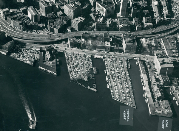
Once at the heart of Boston’s sea trade, in the late 1960s, India Wharf—to the left of Central Wharf—served as a parking lot, wedged between the six-lane Central Artery and a filthy harbor.
Courtesy of City of Boston Archives
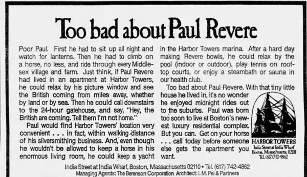
Early newspaper ads, like this one from the Boston Globe on June 23, 1971, encouraged people to “Be far-sighted,” to “Return to the Sea,” and drew on legends Paul Revere and Herman Melville.
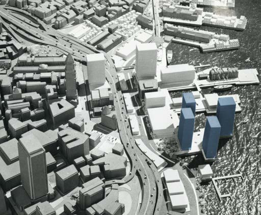
A plan proposed by the city in the early 1960s called for four shorter towers on India Wharf. This changed to three 40-story towers and ultimately two. Architect Henry Cobb lamented the change, explaining that two towers “don’t have the same compositional interest” as his pinwheel plan. But it did create more open space.
Courtesy of City of Boston Archives
Sign Location

More …
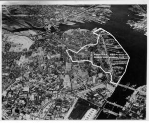
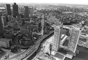
Aerial image shows the area included in the Downtown Waterfront—Faneuil Hall Renewal Project in the early 1960s.
Henry Cobb went on to design the U.S. District Court House in South Boston, across the harbor from Harbor Towers. He also designed the glass tower in Copley Square that used to be known as the John Hancock Tower.
The term comes from the French for raw concrete, béton brut, and has nothing to do with brutality. Its monumental forms are meant to convey power and stability in civic buildings, reflecting the Great Society’s ambitions for the public realm. Many of its practitioners were postwar European immigrants and intellectuals.
New England Aquarium, Government Center, the Christian Science Center, as well as several buildings at MIT, Harvard University and Boston University.
By the mid 1970s, concrete and the labor involved in cast-in-place concrete became prohibitively expensive. Architectural concrete is rare today.
Community activists. Colonial law. Political will. New state regulations. The combination created the 43-mile Boston Harborwalk–a public path, stretching from Logan Airport through seven neighborhoods to the Neponset River. In 1978, the Massachusetts Office of Coastal Zone Management (CZM) sought to improve public access to the waterfront. They succeeded by integrating early Colonial laws into new state regulations.
In the decades that followed, community activists, city and state government, and developers of shoreline projects have worked together to ensure the Harborwalk is always constructed along the waterfront. Some sites also provide public amenities–bathrooms, meeting places, kayak launches,
etc. The result is a fabulous path welcoming residents and visitors to our vibrant clean harbor.
Early Colonial laws established public right of access along tidelands to protect citizens’ rights to fish, hunt, and navigate at sea and along the shorefront. These laws go back even further: They stem from Roman law, which was incorporated into English law and brought over to Massachusetts by English
settlers. Then, in the 1640s, Massachusetts Bay Colony passed laws permitting private docks in the intertidal area (between low and high tide) as long as public access was retained. Almost all of Boston’s waterfront is filled land that was once the intertidal area. This, together with the centuries-old legal right of access, served as the underpinnings for the 1978 CZM regulations.
Resources
- For more on Brutalist architecture
- https://en.wikipedia.org/wiki/Brutalist_architecture
- https://mymodernmet.com/brutalist-architecture/
- Boston Globe archives at Northeastern University
- Keohane, Joe. “Towering Contradictions,” Boston Magazine, February 2008, p 112-115.
- Kifner, John. “On Boston Waterfront, Instant Neighborhood Glitters,” The New York Times, October 23, 1976.
- Pasnik, Mark; Michael Kubo, and Chris Grimley. Heroic: Concrete Architecture and the New Boston. The Monacelli Press, 2015.
- Yulis, Anthony. “Harbor Apartments 2 Years Away,” Boston Globe, February 7, 1969.
- Yulis, Anthony. “Harbor Apartments “Going Like Hot Cakes,” Boston Evening Globe, April 8, 1971.
- Yulis, Anthony. “Apartments on waterfront draw large Boston crowds,” Boston Globe, April 9, 1971.Yulis, Anthony. “Harbor Towers 75% rented,” Boston Sunday Globe, July 29, 1973.