Ship Repair

in East Boston

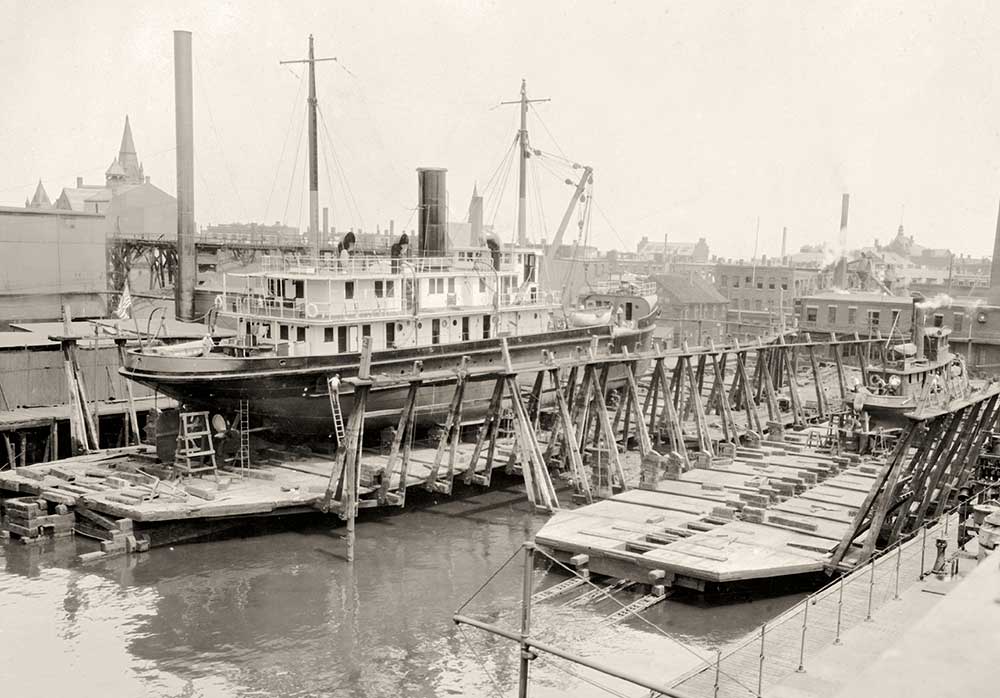
The 1928 photograph taken from the water shows the larger vessel on the 2000-ton double-track marine railway–the closer of the two railways visible ahead. At the time, it was the largest railway in Boston and second largest in the country. Crandall Dry Dock Engineers designed and built the marine railways on this site and moved their office here in 1891.

Photo courtesy of MIT Museum

State-of-the-art shipyard facilities on this site provided repair and maintenance services from 1854 to about 1950. By 1858, Samuel Hall’s East Boston Dry Dock Company included a steam-powered floating dry dock capable of lifting 500-ton ships. Its 600-foot-long marine railway had a cradle with an unprecedented capacity of 1000 tons. Railways with capacities of 1500, 2000, and 2500 tons were built later–all by Crandall Dry Dock Engineers.

In front of you are remnants of the marine railways built in 1890 and 1892. A vessel in need of repair was floated over a timber cradle, which rested on cast-iron rollers on top of the tracks. Once secured, the vessel was hauled up the rails above the tidal zone.

Innovative design and simplicity of operation with minimum manpower contributed to the shipyard’s success. Industrial era improvements such as wrought iron chains and steam-powered winches had replaced ropes, men, and horses. Despite economic downturns, a devastating waterfront fire in 1861, and the decline in local shipbuilding, ship repair thrived here and along Marginal Street.

East Boston Dry Dock Company stock certificate

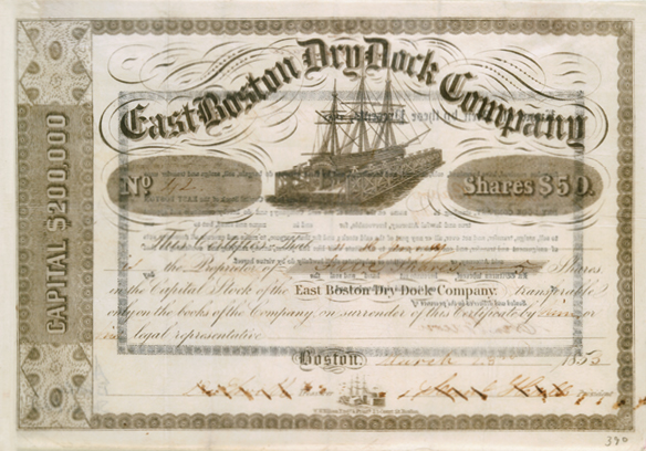
East Boston Dry Dock Company was incorporated in 1847 and sold to Atlantic Works in 1902. The stock certificate may show a sectional dry dock patented and constructed by Phineas Burgess.

Photo courtesy of the Boston Athenaeum

East Boston Dry Dock Company ad

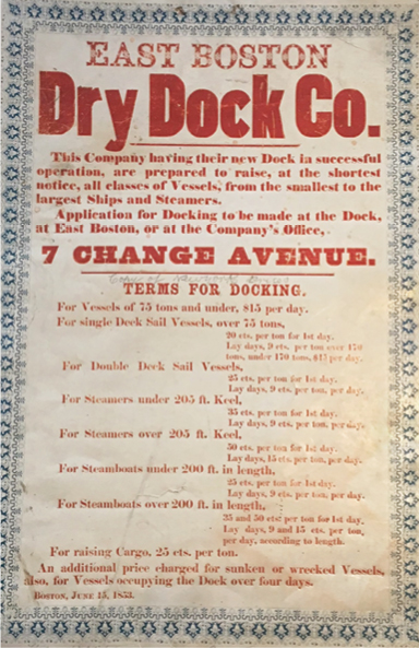
East Boston Dry Dock Company ad.

Photo courtesy of the Massachusetts Historical Society

An 1892 map that shows the location of the two marine railways that had just been completed

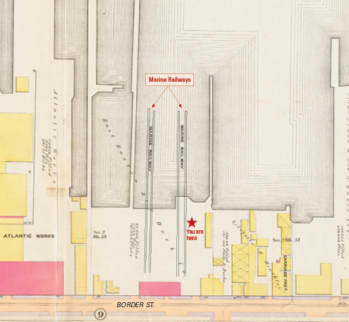
The 1892 map shows the location of the two marine railways that had just been completed. They stretch hundreds of feet into the harbor.

Detail from map by G. W. Bromley & Co. Reproduction courtesy of the Norman B. Leventhal Map Center at the Boston Public Library

Crandall Dry Dock Engineers' premier diver, George Landrigan

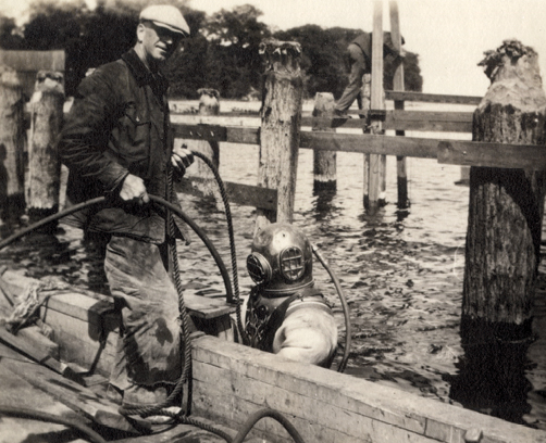
Crandall Dry Dock Engineers’ premier diver, George Landrigan, helped build, inspect, and maintain underwater segments of the marine railways. He also assisted with the docking of vessels. He is shown here with his tender, who directed Landrigan’s movements and monitored his safety.

Photo courtesy of the University of Vermont Bailey Howe Library, Special Collections

Sign Location

More …

Over the course of 150 years, under five generations of Crandalls, the company rose to national and international prominence in the marine railways industry. Crandall Dry Dock Engineers (whose name changed though it always included “Crandall”) has built more than 250 marine railways in the United States, Canada, & abroad.

http://www.crandalldrydock.com/history_new.htm

The development of modern marine railway technology in the early 19th century dramatically changed the nature of shipbuilding and repair. It became possible for smaller shipyards with fewer financial resource to compete with larger ones that could afford to build expensive dry docks, like Dry Dock #1 in Charlestown Navy Yard. Constructing a marine railway cost about one-tenth of constructing a basin dry dock. Moreover, a marine railway was simpler and cheaper to operate. A marine railway’s principal advantages: 1) a vessel could be hauled quickly; 2) the railway track could be fitted to the natural slope of the shore; 3) a vessel could be transferred to and from the shore with relative ease; 4) if the vessel was a little longer than the cradle, it didn’t matter; 5) it was easy for workers to access and work on the vessel.

(adapted from the Public Archaeology Laboratory, Inc. Report #3333, January 2018. lnw)

The two-track marine railway visible from the Harborwalk on the right had a 250-foot-long cradle. The marine railway on the left had one that was 135 feet long. Almost half of the longer cradle was recovered during site work in 2017 and 105 feet of the 135-foot cradle. However all the remains were badly deteriorated.

Both marine railways visible at the site underwent several reconditionings in their 60 to 90 years of service. They were among the longest-working marine railways in the country. The typical “life-span” of a railway was 25 years.

(adapted from the Public Archaeology Laboratory, Inc. Report #3333, January 2018. lnw)

Atlantic Works was founded in 1853 by machinists from Otis Tufts’ machine shop on Summer Street, where Clippership Wharf now stands. They built boilers and marine engines for steamships. After Atlantic Works acquired East Boston Dry Dock Company, it became the largest private ship repair facility in Boston. In 1922 it merged with the Bertelson & Peterson Company and added a large steel floating dry dock to the facility. In 1928, Atlantic Works was purchased by Bethlehem Shipbuilding Corporation, who had already purchased Simpson Dry Dock along Marginal Street a few years earlier. Bethlehem sold this shipyard about 1950 but continued to own the former Simpson yard until 1982.

lnw June 2018

Community activists. Colonial law. Political will. New state regulations. The combination created the 43-mile Boston Harborwalk–a public path, stretching from Logan Airport through seven neighborhoods to the Neponset River. In 1978, the Massachusetts Office of Coastal Zone Management (CZM) sought to improve public access to the waterfront. They succeeded by integrating early Colonial laws into new state regulations.

In the decades that followed, community activists, city and state government, and developers of shoreline projects have worked together to ensure the Harborwalk is always constructed along the waterfront. Some sites also provide public amenities–bathrooms, meeting places, kayak launches,
etc. The result is a fabulous path welcoming residents and visitors to our vibrant clean harbor.

Early Colonial laws established public right of access along tidelands to protect citizens’ rights to fish, hunt, and navigate at sea and along the shorefront. These laws go back even further: They stem from Roman law, which was incorporated into English law and brought over to Massachusetts by English
settlers. Then, in the 1640s, Massachusetts Bay Colony passed laws permitting private docks in the intertidal area (between low and high tide) as long as public access was retained. Almost all of Boston’s waterfront is filled land that was once the intertidal area. This, together with the centuries-old legal right of access, served as the underpinnings for the 1978 CZM regulations.

Resources

  • Public Archaeology Laboratory, Inc. Report t #3333 for Boston East, January 2018.
  • Seasholes, Nancy & The Cecil Group. Sites for Historical Interpretation on East Boston’s Waterfronts. Boston: Boston Redevelopment Authority, 2009.
  • Seasholes, Nancy. Gaining Ground: A History of Landmaking in Boston. Cambridge, MA: The MIT Press, 2003.
  • Sumner, William H. History of East Boston: With Biographical Sketches of its Early Proprietors, and an Appendix. Boston: William H. Piper and Company, 1858.

Acknowledgments

  • Translation and recording thanks to the generosity of the Boston Marine Society
  • Our gratitude to the Perkins School for the Blind and David W. Cook for their partnership in creating the audio files.