Overseas Via Hoosac Tunnel Docks
in Charlestown

The 1900 map, though not to scale, shows the Boston & Maine Railroad’s integral role in Boston’s sea trade. About half of the city’s foreign trade at the time took place here at Hoosac Tunnel Docks.
Boston & Maine Railroad
When the Hoosac Tunnel was completed in northwestern Massachusetts in 1875, it transformed Boston Harbor’s foreign trade for decades. The tunnel connected the Fitchburg Railroad terminal here on Charlestown’s waterfront to the country’s heartland more than a thousand miles away. Huge shipments of grain and livestock could be transported by rail to the newly named Hoosac Tunnel Docks and then by steamship around the world.
In the 1880s, Hoosac Tunnel Dock and Elevator Company enlarged the wharves, built a grain elevator, sheds, and warehouses. Between 1870 and 1900, Boston’s exports grew from $14 million to $124 million. When the Boston & Maine Railroad took over the Fitchburg Railroad in 1900, Hoosac Tunnel Docks’ reach expanded further.
Boston’s longstanding position as second busiest port in the country ended soon thereafter, however, largely for reasons beyond the city’s control. A 1940s dock and grain elevator renovation briefly revitalized the facility, but it was too small for larger cargo ships. In the late 1900s, the mighty Hoosac Tunnel Docks—renamed Constitution Wharf—began a new life as office buildings and condominiums.
The 1875 map shows how the Fitchburg Railroad already had spurs onto the wharves that preceded Hoosac Tunnel Docks. For decades, an ice shipping business thrived here.
Hopkins map courtesy of the Norman B. Leventhal Map & Education Center, Boston Public Library
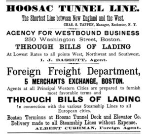
1880s advertisement
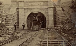
At 4 ¾ miles, Hoosac Tunnel was the longest railroad tunnel in the US when completed in 1875.
Courtesy of North Adams Public Library
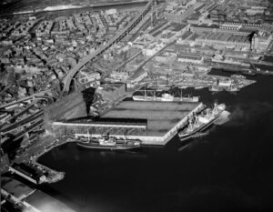
A mid-1900s renovation consolidated docks 5, 6, and 7 as one, and some coastal trade continued at Hoosac Tunnel Docks, but soon larger ships needed longer and deeper docks.
Courtesy of Northeastern University
Sign Location

More …
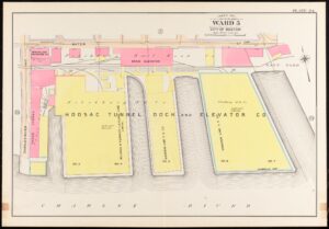
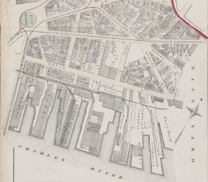
The 1901 Bromley map captures Hoosac Docks at its peak, stretching from just shy of the Charlestown Bridge to the Navy Yard.
Map courtesy of the Norman B. Leventhal Map & Education Center, Boston Public Library
Community activists. Colonial law. Political will. New state regulations. The combination created the 43-mile Boston Harborwalk–a public path, stretching from Logan Airport through seven neighborhoods to the Neponset River. In 1978, the Massachusetts Office of Coastal Zone Management (CZM) sought to improve public access to the waterfront. They succeeded by integrating early Colonial laws into new state regulations.
In the decades that followed, community activists, city and state government, and developers of shoreline projects have worked together to ensure the Harborwalk is always constructed along the waterfront. Some sites also provide public amenities–bathrooms, meeting places, kayak launches,
etc. The result is a fabulous path welcoming residents and visitors to our vibrant clean harbor.
Early Colonial laws established public right of access along tidelands to protect citizens’ rights to fish, hunt, and navigate at sea and along the shorefront. These laws go back even further: They stem from Roman law, which was incorporated into English law and brought over to Massachusetts by English
settlers. Then, in the 1640s, Massachusetts Bay Colony passed laws permitting private docks in the intertidal area (between low and high tide) as long as public access was retained. Almost all of Boston’s waterfront is filled land that was once the intertidal area. This, together with the centuries-old legal right of access, served as the underpinnings for the 1978 CZM regulations.
Resources
- Boston & Maine Railroad Historical Society
- Bunting, W. H. Portrait of a Port: 1852-1914. The Belknap Press of Harvard University Press, 1971.
- Weinbaum, Paul, O. “Hoosac Docks: Foreign Trade Terminal, A Case of the Expanding Transportation System Late in the Nineteenth Century,” A Special History Study. Boston National Historical Park, 1985.
- Bromley 1901 Atlas link https://collections.leventhalmap.org/search/commonwealth:tt44pw17f
Acknowledgments
- Our gratitude to the Perkins School for the Blind and Thomasine Berg for their partnership in creating the audio files.