Marine Park
in South Boston

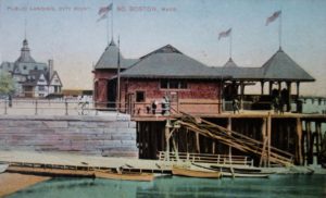
The magnificent half-timbered Head House was designed by Boston City Architect Edmund Marsh Wheelwright to look like a medieval German town hall. Opened in 1896, this City-owned property fell into neglect during the Great Depression. Fire caused extensive damage in 1942 and it was demolished soon after. Castle Island can be seen across Pleasure Bay behind the flagpole.
Courtesy of the Library of Congress
With Boston’s population growing rapidly in the 1870s, new parks were proposed for every neighborhood. Here, at the tip of South Boston, landscape designer Frederick Law Olmsted transformed mud flats and marshlands into Marine Park as part of his Emerald Necklace.
The Head House was the park’s centerpiece. Besides changing rooms for beachgoers, it had two cafés, an ice cream parlor and a large restaurant where German bands played on weekends. “My mother said they’d go on Sunday afternoons and sing along,” a long-time South Boston resident remembered.
Steamboats shuttled passengers from a public dock to Castle Island, before its connection to the mainland. The crossing took seven minutes. The stonework of the pier is still visible along the beach to the right.
South Boston historian Thomas O’Connor wrote: “Thousands of families from all over the Boston area travelled [to Marine Park] in open-air trolleys … They would come loaded with blankets, bathing suits and huge box lunches….” One hot weekend in 1910 brought 150,000 visitors.
A public dock, originally called City Landing, became known as Kelly’s Landing after an eatery famous for its fried clams opened there in 1927. “It was a landmark,” recalled one old-timer. ”Everybody would say, ‘Meet me at Kelly’s.’” The restaurant closed in 1974.
Postcard courtesy of Jim Sullivan, Postcard History of South Boston
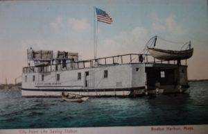
As the popularity of Marine Park and Pleasure Bay grew, so did the number of drownings, mainly from boating accidents. A floating lifesaving station with a rescue boat hung at its stern was commissioned in August 1896 and anchored in Dorchester Bay. A 10-man crew lived on the boat from May to November. It remained in service until World War II.
Postcard courtesy of Jim Sullivan, Postcard History of South Boston
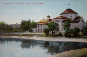
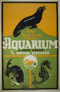
The City-owned Boston Aquarium once stood on the rise behind the ice rink. It opened in 1912 and attracted 15,030 visitors on its first Sunday. “I was enthralled by the seals swimming in a large pool under the dome,” recalls one visitor.” The Aquarium closed in 1954.
Postcard courtesy of Jim Sullivan, Postcard History of South Boston; poster courtesy of the Boston Athenaeum
Sign Location

More …
Resources
- O’Connor, Thomas H., South Boston My Home Town (second edition), Northeastern University Press, 1988, 1994.
- Reid, William J. Castle Island and Fort Independence. Trustees of the Public Library of the City of Boston, 1995.
-
Sullivan, Jim, South Boston, Postcard History Series, Arcadia Publishing, 2007.
-
Seasholes, Nancy S., Gaining Ground, A History of Landmaking in Boston, MIT Press, 2003.
Acknowledgments
- This sign is made possible by funding from a Boston Community Preservation Act grant.
- Warm thanks to historians at the Castle Island Association for their guidance and expertise in creating this sign and to the Department of Conservation and Recreation for their partnership.
- Thank you to Brendan Albert and Kate Gutierrez for generously funding Spanish translations for the Castle Island/Pleasure Bay signs.
- Our gratitude to the Perkins School for the Blind Recording Studio and Thomasine Berg for their partnership in creating the audio files.