First Street: The Original Shoreline
in South Boston

Detail from 1806 map by Caleb Parry Wayne captures Dorchester Neck (population: 60) and the flats to its north shortly after the area was annexed by Boston and renamed South Boston. The star indicates where you are now.
Courtesy of the Norman B. Leventhal Map & Education Center at Boston Public Library
In 1804, Boston annexed the thinly populated peninsula known as Dorchester Neck and renamed it South Boston. This spot was on the South Boston Flats: a vast expanse of salt marsh laced with inlets. The land to the north and northwest of here today—the Fort Point Channel and Seaport neighborhoods—as well as the Reserved Channel are all man-made.
By 1845, South Boston’s population had grown to 10,020. First Street and a section of Second Street ran along the original shoreline. Glassmakers, shipbuilders, and ironworkers established businesses along the waterfront, built wharves, and began to fill the flats as far as 1,650 feet from the shoreline, as the law permitted. Bay State Iron Company created the land in front of you, using a long-standing Boston technique. They enclosed an area of shallow water with a sea wall and then deposited fill on the inland side. That sea wall is still visible along the Reserved Channel.
In the decades that followed, landmaking expanded South Boston from its original 580 acres to about 1,600 acres. The once rural peninsula was completely transformed.
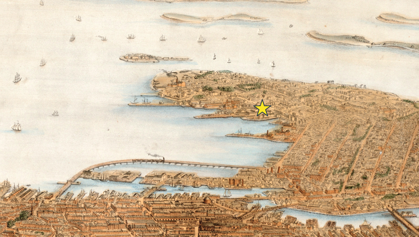
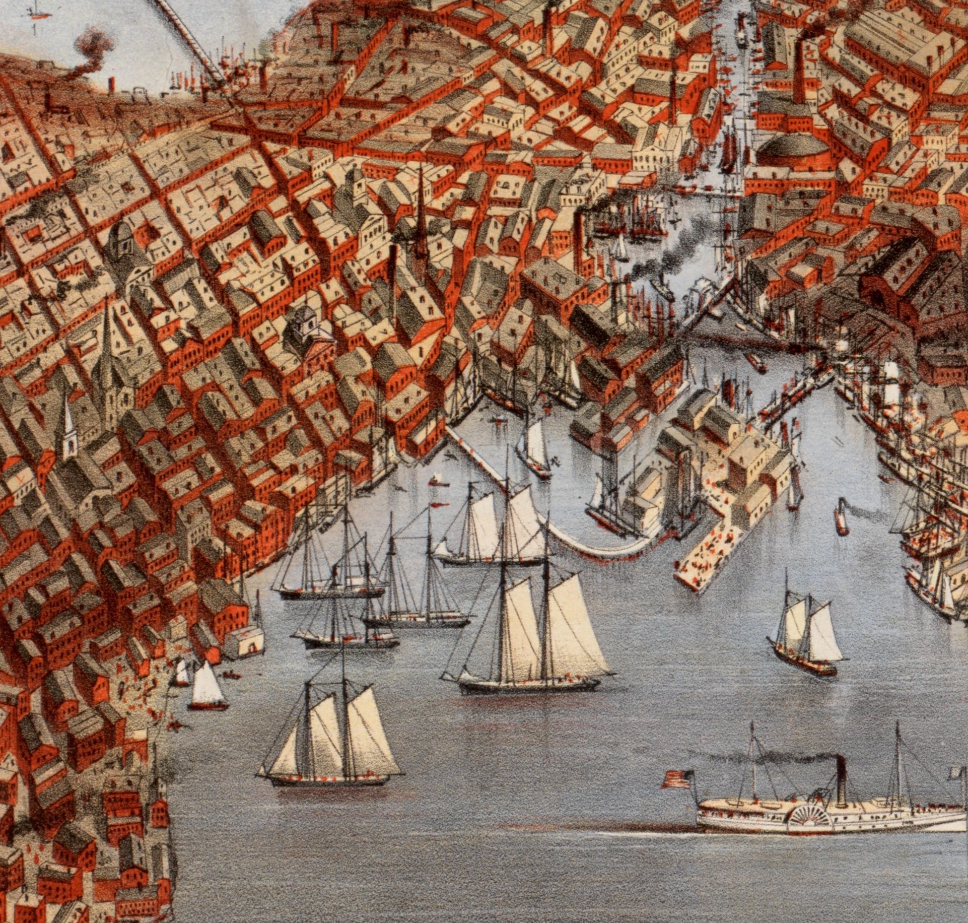
This detail from B. F. Nutting’s 1866 bird’s eye view, shows multiple landmaking projects north of First Street in South Boston. In the foreground, note the huge wharf begun by Boston Wharf Company in the 1830s. It formed the east side of today’s Fort Point Channel. In 1855, the Boston & New York Central Railroad built the almost mile-long pile rail bridge to its depot near present day South Station. Today, South Boston Bypass Road crosses South Boston where the tracks once ran.
Courtesy of the Norman B. Leventhal Map & Education Center at Boston Public Library
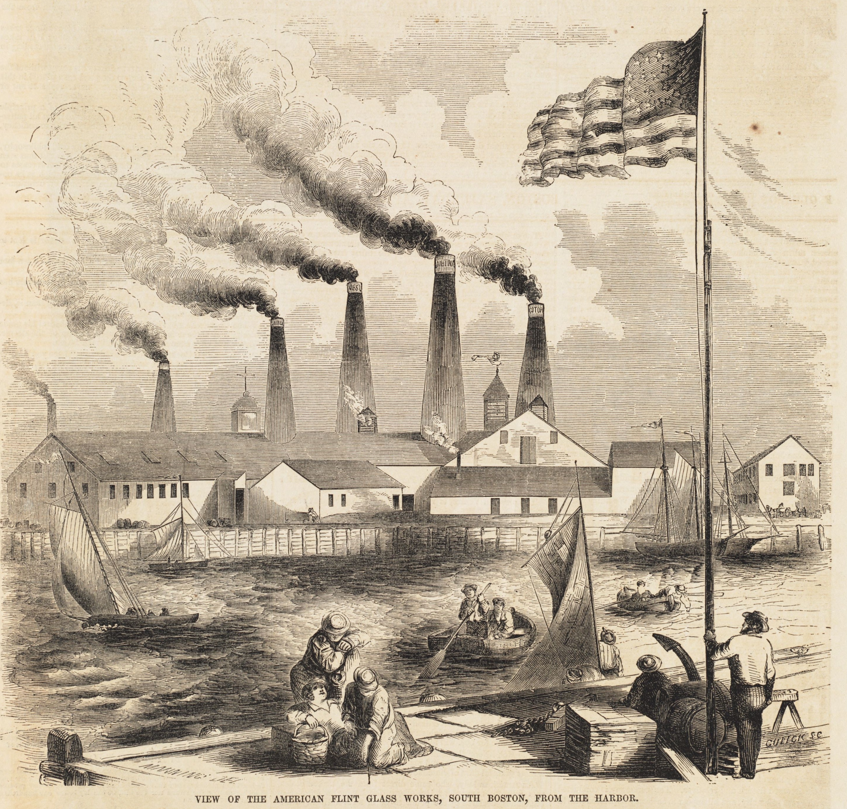
A short distance to the east and west of here two glassmaking factories were among several that built on, or very close to, South Boston’s original waterfront. American Flint Glass Works, pictured here, stood on East First Street. Archaeologists uncovered the factory’s footprint in 1997.
Engraving by David B. Gulick printed in April 1853 Gleason’s Pictorial Drawing-Room Companion, Courtesy of Boston Public Library
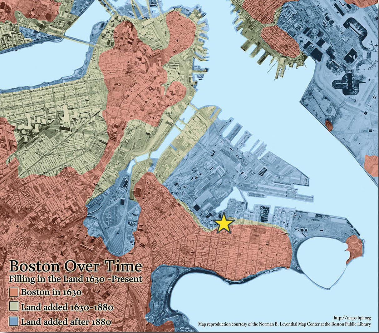
Landmaking projects accelerated after 1880, dramatically altering South Boston. Industrial sites that once hugged the shoreline and looked out over the South Boston Flats are now far inland.
Courtesy of the Norman B. Leventhal Map & Education Center at Boston Public Library
Sign Location

More …
This is a complicated story because many different entities were involved at different times—including the state, federal government, and railroad companies. For an in depth look at South Boston landmaking, please refer to Gaining Ground: A History of Landmaking in Boston by Nancy S. Seasholes.
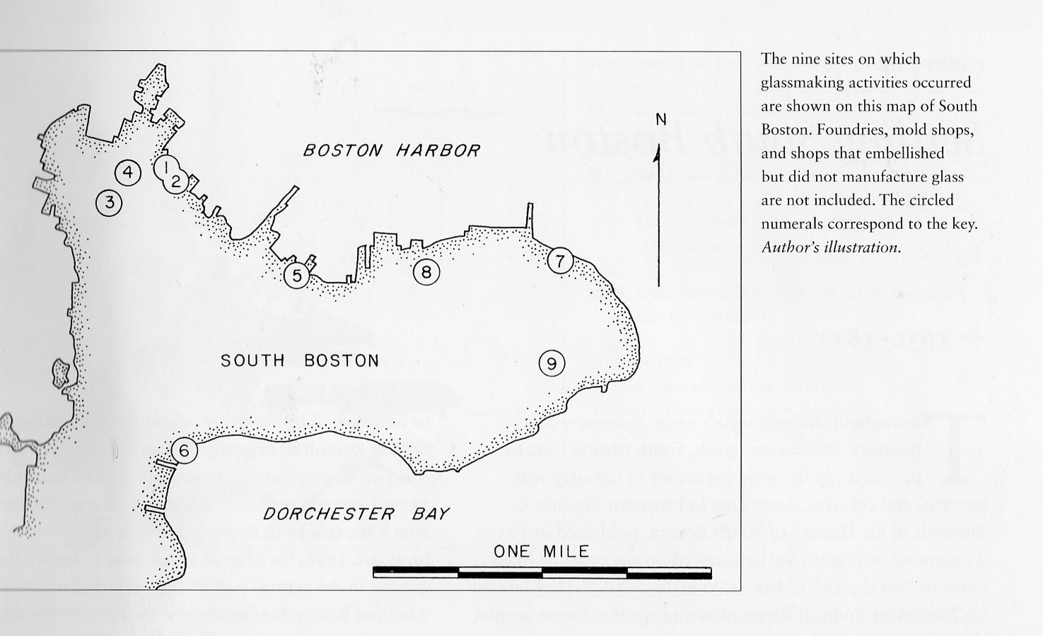
Glass manufacturers were among the earliest industries in South Boston. Between 1812, when the first glassworks was established, and the end of the 1800s, there were nine glassmaking sites in South Boston. At those sites, 25 companies were in business at various times. Note how almost all were along the original South Boston shoreline, including #3 and #4, which would have been close to the water before the flats were filled.
Source: Kaiser, Joan E. The Glass Industry in South Boston. University Press of New England, 2009.
This detail from an 1873 bird’s eye view of South Boston, with Fort Point Channel on the right, shows the unfolding changes to South Boston’s shoreline. Bay State Iron Works is in the lower left corner.
American Flint Glass Works was the last company to operate at site #1 on the map by Joan Kaiser. In the late 1990s, the site was involved in the Big Dig project. That project not only put Route 93 underground, built the Ted Williams Tunnel and the Zakim Bridge, it also involved construction of the South Boston Bypass Road, a new surface road connecting the Southeast Expressway to a new section of the turnpike. Construction included cleaning up the contaminated site of the former glassworks. In addition to removing dangerous levels of arsenic, barium, chromium, and lead, workers found misshapen and broken glass objects that had been manufactured at the site. Professional archaeologists were hired to survey the site. Some of the glass remains can be seen at the Massachusetts Archives.
Source: Kaiser, Joan E. The Glass Industry in South Boston. University Press of New England, 2009.
Joan Kaiser’s book, The Glass Industry in South Boston, gives a detailed look at this important 19th century industry. In short, American Flint Glass Works employed 240 men and 20 women. The company largely made “inexpensive objects such as pressed tableware” and “lightweight bottles,” writes Ms. Kaiser. The company employed many new Irish immigrants and paid lower wages than some other South Boston glass manufacturers. Ms. Kaiser speculates this may have been because the company was not known for high quality glass and didn’t need highly skilled glass cutters, who were paid better.
Resources
- Kaiser, Joan E. The Glass Industry in South Boston. University Press of New England, 2009.
- Seasholes, Nancy S. Gaining Ground: A History of Landmaking in Boston. The MIT Press, 2003.
- Toomey, John & Edward Rankin. History of South Boston (Its Past and Present) and Prospects for the Future. Published in Boston by the authors, 1901.
Acknowledgments
- Deep thanks to Nancy Seasholes for sharing her expertise and for all her support.
- Our gratitude to the Perkins School for the Blind and David W. Cook for their partnership in creating the audio files.