Battle of Bunker Hill
in Charlestown

“Plan of the Battle on Bunker Hill,” by British General John Burgoyne, published in London, fall 1775. The Redcoats, under the command of General William Howe, approached from the shoreline. Provincial soldiers at the redoubt were under the command of Colonel William Prescott.
Courtesy of the Library of Congress
June 17, 1775, HMS Lively lay at anchor between Boston and Charlestown. At dawn, her lookout detected the redoubt—a fortlike structure—provincials had hastily built overnight atop Breed’s Hill. Lively’s crew began firing their cannon at the “rebels,” but failed to intimidate them.
Early afternoon, British long boats, bearing armaments and hundreds of regulars, rowed past what is now Pier 8 up to the shoreline a few yards inland. Soon the cannon roar intensified–from British warships offshore and the battery across the harbor on Copp’s Hill. Charlestown was aflame.
The Redcoats advanced in orderly formation. “An incessant stream of fire poured from the rebel line,” a British soldier reported. They fell back. Finally on their third attempt, as provincials ran out of gunpowder, British troops breached the provincials’ defenses, forcing them to retreat.
The provincials suffered 405 casualties and lost control of Charlestown’s strategic hills. But more than a thousand Redcoats had been killed or wounded. “The success is too dearly bought,” wrote General Howe. Nine months later British troops evacuated Boston.
“the Enemy [the Redcoats] Landed and … Soon planted their Cannon and began the fire & advancing up to our fort after they Came within gunshot we fird & then Ensud a very hot Engagement after a number of shots passed the Enemy Retreated…. They advanced again & we Began A hot fire for A short time the Enemy Scaling our walls and the number of our men being few we was ordered to Retreat…”
From the journal of Thomas Boynton, who served in the Massachusetts militia
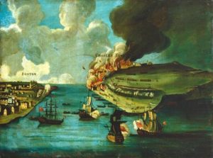
General Howe gave the order for the town of Charlestown to be burned to the ground shortly before the battle began. Almost all residents had left as the threat of danger became clear.
Courtesy of the National Gallery of Art
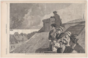
Boston citizens watched the battle unfold from rooftops and hills.
Illustration based on Winslow Homer drawing, Harper’s Weekly, June 26, 1875
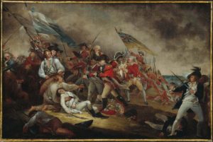
The focus of John Trumball’s painting is the death of Dr. Joseph Warren, a key player in events leading up to the battle. Trumball also includes two of more than 100 men of color who served at Bunker Hill. On the far right, Asaba, enslaved by Lt. Thomas Grosvenor, stands behind him. Just below the flags on the left it’s believed is Peter Salem, a Black freeman.
“We mourn for the citizen, the senator, the physician and the warrior.” Abigail Adams writing of Dr. Joseph Warren’s death to her husband, John Adams, July 5, 1775.
Painting courtesy of Boston Museum of Fine Arts
Sign Location

More …
Resources
- Harris, John. “The Battle of Bunker Hill,” The Boston Globe, June 8, 1975.
- Philbrick, Nathaniel. Bunker Hill, A City, A Siege, A Revolution. Viking, 2013.
- Quintal, George. Patriots of Color, ‘A Peculiar Beauty and Merit,’ African Americans and Native Americans at Battle Road & Bunker Hill. National Park Service, 2002.
- Wheildon, William Willder. New History of the Battle of Bunker Hill, June 17, 1775, Its Purpose, Conduct, and Result. Lee & Shepard, 1875.
Acknowledgments
- Warm thanks to Professor Robert Allison and National Park Service ranger Dan Gagnon for their review of the sign.
- Our deep gratitude to Ann and Chuck Legasse for their enthusiasm and commitment to celebrating the former Navy Yard’s history.