View of Boston 1848
in East Boston

Image courtesy of the Boston Athenaeum
Sign Location

More …
In 1915, the Custom House tower was added to the domed building visible on the 1848 panorama. It was the first skyscraper built in Boston and remained the only one until the old John Hancock building was completed in 1949. As a federal building, the Custom House tower didn’t have to adhere to Boston building height restrictions, which were 125 feet. The tower is 495 feet high.
The first two floors of the Custom House are open to the public. Another hidden gem is the observation deck on the 26th floor, open to the public 2 p.m. and 6 p.m. Saturday through Thursday for fabulous 360-degree views of the city and harbor. The same pair of peregrine falcons return annually to nest on the 30th floor. You can watch their chicks grow on a Mass Audubon camcorder.
The last ferry crossed in 1952. People travel between East Boston and the downtown on the Blue Line or by car—through tunnels dug under the harbor.
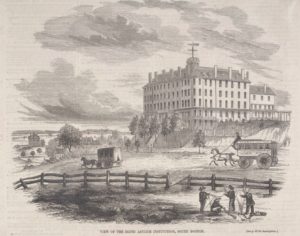
The Perkins School for the Blind, originally known as the New England Asylum for the Blind, was the first school for the blind in the United States. It opened its doors to students in 1832. A year later, it moved to a house on Pearl Street donated by Thomas H. Perkins. With an ever-expanding student population, by the late 1830s, the school needed a new home. With permission from Mr. Perkins to sell his house, the school purchased what had been the Washington Hotel on Dorchester Heights in South Boston—the building you see on the panorama—and moved there in 1839. At this time, the school took on the Perkins name, in gratitude for his support. For more than 70 years, despite various challenges, the school remained in South Boston. In 1912, Perkins School for the Blind moved to its present campus along the Charles River in Watertown.
Courtesy of the Boston Athenaeum
Community activists. Colonial law. Political will. New state regulations. The combination created the 43-mile Boston Harborwalk–a public path, stretching from Logan Airport through seven neighborhoods to the Neponset River. In 1978, the Massachusetts Office of Coastal Zone Management (CZM) sought to improve public access to the waterfront. They succeeded by integrating early Colonial laws into new state regulations.
In the decades that followed, community activists, city and state government, and developers of shoreline projects have worked together to ensure the Harborwalk is always constructed along the waterfront. Some sites also provide public amenities–bathrooms, meeting places, kayak launches,
etc. The result is a fabulous path welcoming residents and visitors to our vibrant clean harbor.
Early Colonial laws established public right of access along tidelands to protect citizens’ rights to fish, hunt, and navigate at sea and along the shorefront. These laws go back even further: They stem from Roman law, which was incorporated into English law and brought over to Massachusetts by English
settlers. Then, in the 1640s, Massachusetts Bay Colony passed laws permitting private docks in the intertidal area (between low and high tide) as long as public access was retained. Almost all of Boston’s waterfront is filled land that was once the intertidal area. This, together with the centuries-old legal right of access, served as the underpinnings for the 1978 CZM regulations.
Resources
No additional resources at this time
Acknowledgments
- Warm thanks to Nancy Seasholes and Professor Robert Allison for their assistance