Transformed Tidal Flats
in South Boston

Like most large piers in Boston around 1900, Pier 4 and Piers 1 and 2 (now Fan Pier) were owned by a major railroad company. The New York, New Haven & Harford Railroad Company, whose terminal is pictured here, was widely known as “the New Haven.”
Print by George H. Walker & Co., 1903. Courtesy of the Library of Congress
In 1873, major seawall construction and filling began between Fort Point Channel and here, part of a massive landmaking project on the South Boston Flats. Soon, a vast rail yard covered the former mud flats and salt marsh. To facilitate freight handling, tracks stretched onto Pier 4—built in the 1880s—and the two piers that today comprise Fan Pier. A series of railroad companies, culminating with the New Haven, owned both land and piers.
Coal was a vital regional power source at the time. In 1900, for example, four million tons were shipped up the coast to Boston. A portion was unloaded here to be transported by freight car. Other goods arriving at Pier 4 included imported wool, stored in warehouses nearby, animal hides destined for shoemaking factories, and cotton headed for mills.
The New Haven went bankrupt in 1935, reorganized, and was bankrupt again in 1961. In the years that followed, tracks were torn up and replaced by parking lots. Around 2010, an unprecedented building boom began to transform what was once tidal lands yet again.
The 1817 survey of Boston Harbor shows a smattering of houses in a rural South Boston and the enormous tidal flats known as South Boston Flats. By the end of the 19th century, the flats were filled. Across the harbor, Bird and Governor’s Islands would become part of Logan Airport.
Boston Harbor Chart by Alexander Wadsworth, published in 1819. Courtesy of the Norman B. Leventhal Map & Education Center, Boston Public Library
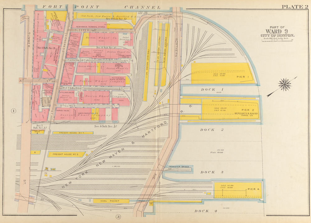
Everything shown on this 1919 map is new land. The original South Boston shoreline was roughly along First Street. Total landmaking in South Boston was second only to what was required to create Logan Airport.
Atlas of the City of Boston, South Boston by G. W. Bromley & Co., Courtesy of the Norman B. Leventhal Map & Education Center, Boston Public Library
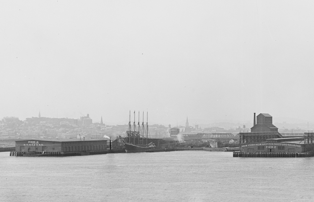
New England’s high demand for coal after the Civil War drove the construction of ever-larger schooners to carry coal up the coast from Virginia. In this photograph taken from East Boston, a five-masted schooner is docked at Pier 4, delivering coal. The tall building to the right is a grain elevator.
Photograph by Henry G. Peabody, Detroit Publishing Co, 1906. Courtesy of the Library of Congress
Sign Location
More …
Changes to the South Boston Flats began in the late 1830s with the construction of a 12-foot high seawall and a large wharf by Boston Wharf Company, roughly parallel to Boston’s shoreline and now the site of Gillette. By 1845, the wharf stretched 1,650 feet north of the original high water mark along First Street. Ten years later, the company was authorized to extend the wharf all the way to today’s Northern Avenue.
Source: Seasholes, Nancy S. Gaining Ground: A History of Landmaking in Boston. The MIT Press, 2003.
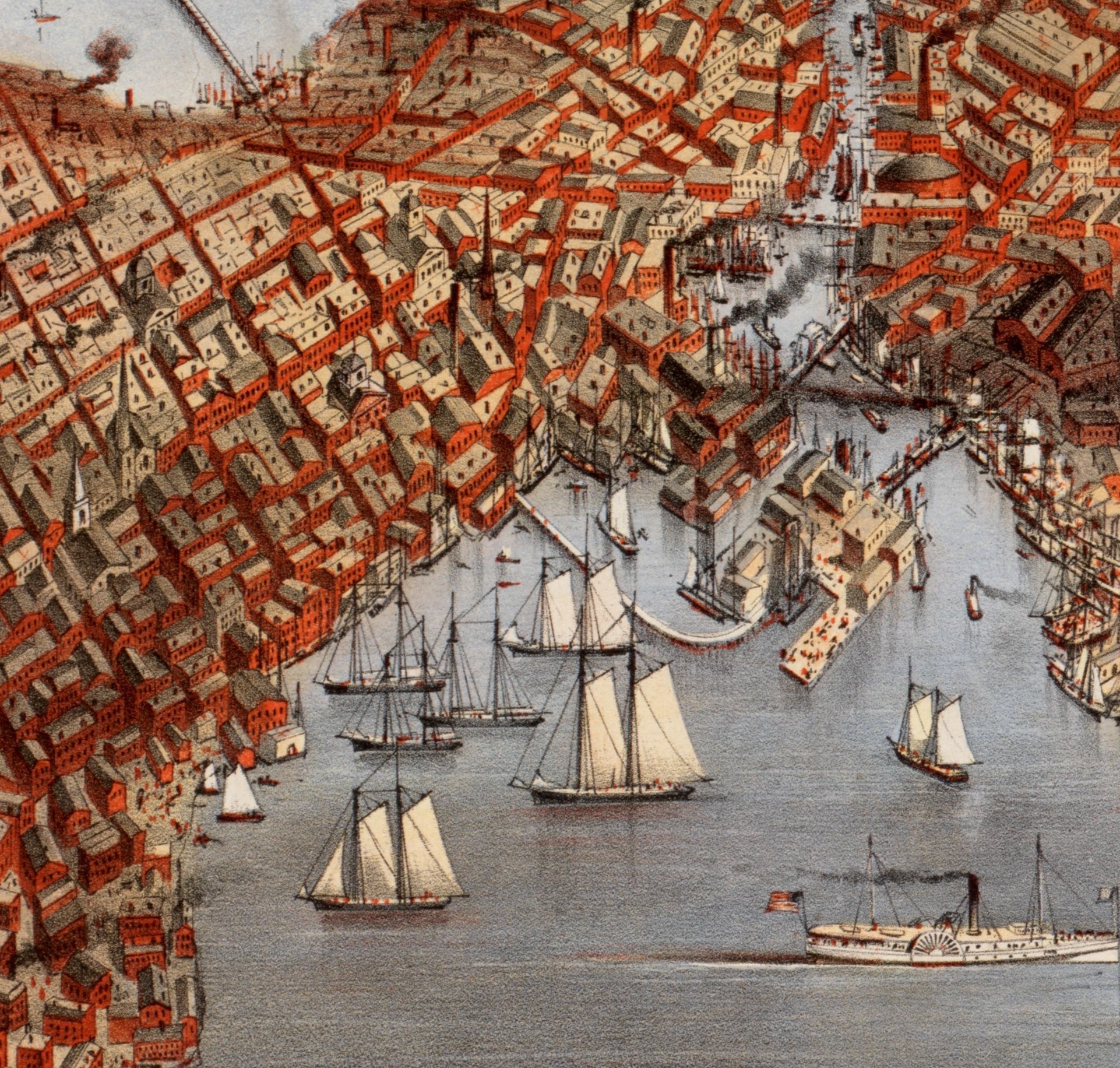
This detail from an 1873 bird’s eye view of South Boston, with Fort Point Channel on the right, shows the unfolding changes to South Boston’s shoreline.
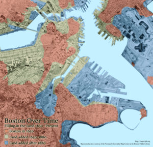
The blue area shows the enormous amount of landmaking in South Boston beginning late in the 19th century.
Note: The map has a small error. On the 1630 part of the map, there shouldn’t be a canal across Jeffries Point in East Boston. It would also be more accurate to say “Filling in tidal flats” to describe what has occurred since 1630 in Boston.
[credit] Map courtesy of the Norman B. Leventhal Map & Education Center at Boston Public LibraryBoston Wharf Company was founded in 1836 with the goal of expanding wharf space and building warehouse facilities to accommodate a thriving sea trade. Thousands of domestic and foreign vessels were sailing in and out of Boston Harbor every year. The company played a significant role in filling the South Boston Flats, making almost 100 acres of land. The company also laid out streets and added infrastructure. Beginning in the late 1880s, Boston Wharf Company pivoted to commercial real estate. The company began to build five- and six-story warehouses and light manufacturing buildings on their land. These buildings now comprise the Fort Point Channel Landmark District.
Sources: Toomey, John & Edward Rankin. History of South Boston (Its Past and Present) and Prospects for the Future. Published in Boston by the authors, 1901.
“Fort Point Channel Landmark District” Study Report amended December 9, 2008. Boston Landmarks Commission, City of Boston.
When the Boston Wharf Company was building its wharf between the 1830s and 1850s, some thought the wharf cut off the force of the two daily outgoing tides that were believed to help deepen shipping channels in the harbor while others thought the wharf channeled the force of the ebb tide into the Fort Point Channel, helping to keep it open. In 1859, the city of Boston requested the federal government make a scientific study of Boston Harbor. The U.S. Commissioners on Boston Harbor decided that the Boston Wharf Company Wharf did improve the Fort Point Channel and recommended building a seawall around all the South Boston Flats, later agreeing the flats behind the seawall could be filled. The commissioners issued their plan in 1866 and after much deliberation and many revisions, a four-way agreement among the Commonwealth of Massachusetts, the city of Boston, Boston Wharf Company, and Boston & Albany Railroad Company was reached in 1873. Work began immediately.
Sources: Seasholes, Nancy S., Gaining Ground: A History of Landmaking in Boston. The MIT Press, 2003.
Toomey, John & Edward Rankin. History of South Boston (Its Past and Present) and Prospects for the Future. Published in Boston by the authors, 1901.
Twenty-Ninth Annual Report of the Harbor & Land Commissioners for the Year 1907. (available online)
The original pier was 1,050 feet long. On the side where coal deliveries arrived, the water was 32 feet deep. The two-story wood and steel building that stood here (before Anthony’s Pier 4 restaurant) was 480 feet long and 160 feet wide. In addition there was a “coal pocket” slightly inland [see Bromley insurance map] that had a capacity of 12,800 tons of coal.
Source: “Twenty-Ninth Annual Report of the Harbor & Land Commissioners for the Year 1907.”
Yes. By 1893, the New York, New Haven, & Hartford Railroad Company—the New Haven—had absorbed smaller railroad companies like Old Colony and Boston & Providence and essentially had a monopoly on train service between New York City and Boston. The New Haven began to quickly consolidate their Boston terminals. South Station became the passenger terminal. The Boston Freight Terminal, close to South Boston piers on filled mud flats, handled all the New Haven’s freight. That terminal was greatly expanded and modernized during the first two decades of the 20th century.
Sources: Brown, C.A. “South Boston and the New Haven,” Shoreliner, 1986.
Liljestrand, Robert A. The New Haven Railroad’s Boston Division. Published by Bob’s Photo, 2001.
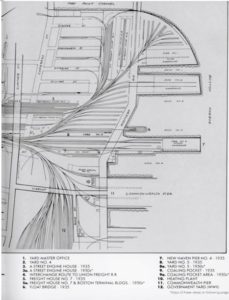
The plan shows the area as an active freight terminal well into the 1950s.
New Haven Railroad’s April 1936 booklet “Arranged Freight Train Service” reads: “At Boston, the New Haven Railroad has one of the largest [freight] terminals in the United States with 12 freight houses containing more than 300,000 sq. ft. of floor space and tracks for placing 600 cars; also bulk tracks for loading and unloading 1350 cars daily.”
Reprinted in Lynch, Peter. New Haven Railroad. MBI Publishing Co., 2003. p.132.
Even though after 1912 freight revenues always exceeded passenger revenues, New Haven Railroad was better known for its passenger service than as a freight carrier. Peter Lynch writes in New Haven Railroad, “It ran trains with sleeping cars and Pullman parlor cars, branch line trains, commuter trains, mail and express trains… [as well as] passenger ferries to Martha’s Vineyard and Nantucket.”
By the early 1900s, the New Haven dominated the region’s rail transportation. In fact, it was known for many years as the “Consolidated.” But “it could not sustain its overexpansion and resulting debt,” writes Peter Lynch in New Haven Railroad. Nevertheless, its almost century-long history makes for fascinating reading.
Resources
- Boston Landmarks Commission. “Fort Point Channel Landmark District Study Report.” City of Boston, December 9, 2008.
- Brown, C.A. “South Boston and the New Haven,” Shoreliner, 1986.
- Bunting, W.H. Portrait of a Port: Boston, 1852-1914. Belknap Press, Harvard University Press, 1971.
- Gillespie, C. Bancroft. Illustrated History of South Boston. Inquirer Publishing Company, 1900.
- Liljestrand, Robert A. The New Haven Railroad’s Boston Division. Published by Bob’s Photo, 2001.
- Seasholes, Nancy S. Gaining Ground: A History of Landmaking in Boston. The MIT Press, 2003.
- Toomey, John & Edward Rankin. History of South Boston (Its Past and Present) and Prospects for the Future. Published in Boston by the authors, 1901.
- “Thirty-fifth Annual Report of the Board of Harbor & Land Commissioners for the Year 1913.” Boston, MA
- “Twenty-ninth Annual Report of the Harbor & Land Commissioners for the Year 1907.” Boston, MA
- “First Annual Report of the Commission on Waterways & Public Lands: Consolidating Harbor & Land Commission and Directors of the Port of Boston, for the Year 1916.” Boston, MA
Acknowledgments
- Warm thanks to Nancy Seasholes for her expertise and support.
- Our gratitude to the Perkins School for the Blind and David W. Cook for their partnership in creating the audio files.