The Treasured Lagoon
in South Boston

Since 1972, the Harry McDonough Sailing Center has introduced hundreds of kids to the joy of sailing.
Photograph by Deb McCarthy
Joggers, swimmers, walkers, birders, sailors–thousands enjoy “the Lagoon,” as locals call Pleasure Bay. Protected from ocean waves by Castle Island and the man-made causeway, the bay’s flat water is ideal for open-water swimmers. But its location, jutting out to the sea, also captures winds that exhilarate kite boarders and wind surfers.
The Lagoon was a perfect location for South Boston native Harry McDonough to share his love of sailing by establishing a sailing program—free for all kids. “All” meant all. In partnership with the Carroll Center for the Blind, Harry established the first sailing program in the country for children with visual impairments. SailBlind later moved to Charlestown and its sailors went on to participate in international blind sailing regattas.
At the Lagoon, the summer sailing program continues to give kids “the opportunity to learn something new, and for many to discover a passion they never knew they had,” explains Aaron Mulligan. Like many, Aaron learned to sail at the McDonough Center and then became an instructor.
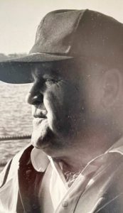
Life-long sailor Harry McDonough (1921-1990) believed “the world looks completely different 50 yards from shore,” his daughter recalled.
Photo courtesy of the McDonough family

As the 1930s photo shows, the beach at Pleasure Bay has drawn crowds for decades.
Courtesy of the Boston Public Library, Leslie Jones Collection
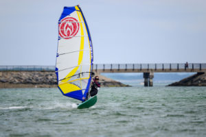
Photo by Alena Ashenberg

Photo by Liz Nelson Weaver
Sign Location

More …
Resources
Harry McDonough obituary, Boston Globe, October 11, 1990.
Interviews with Kate Acton, Denise Cohen, Barbara McDonough MacDonald, Aaron Mulligan, and Steve Sevcik, summer 2021.
O’Neill, Arthur. “SailBlind Program History.” Carroll Center for the Blind.
Acknowledgments
- This sign is made possible thanks to the city of Boston’s Community Preservation Act Fund.
- Friends of the Boston Harborwalk thank the Massachusetts Department of Conservation & Recreation for their partnership.
- Warm thanks to Brendan Albert and Kate Gutierrez for generously funding Spanish translations for the Castle Island/Pleasure Bay signs.
- Our gratitude to the Perkins School for the Blind Recording Studio and Thomasine Berg for their partnership in creating the audio files.