The Narrow Gauge with Wide Appeal
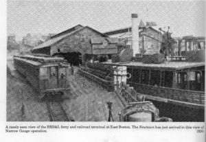
in East Boston
(awaiting installation)

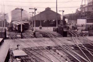
A major feature of the Boston, Revere Beach & Lynn Railroad was the now abandoned, two-track, 400-foot tunnel.
1909 photograph courtesy of the Robert Stanley Collection
A century ago, you could step off a ferry at the next pier over, board the Boston, Revere Beach & Lynn narrow gauge train, and travel along the coast to downtown Lynn.
The idea for the rail line originated with land speculator Alpheus Blake. He sought easy access to land he wanted to develop north of Boston. Men dug a tunnel under Jeffries Point, built trestles over salt marsh, and laid almost 10 miles of 3’ 6”-wide track–all in 100 days. Late July 1875, the first passengers stepped aboard.
The narrow gauge was an immediate success; its 30-minute 20-cent ride convenient and affordable. By 1914, over 7 million passengers a year made it the most heavily traveled and commercially successful rail line of its kind in the country.
Increased dependence on automobiles and the opening of the Sumner Tunnel in 1934 significantly cut into train ridership, eventually forcing the Boston, Revere Beach & Lynn Rail-road to end service in January 1940. A section of its route became part of the MBTA Blue Line.
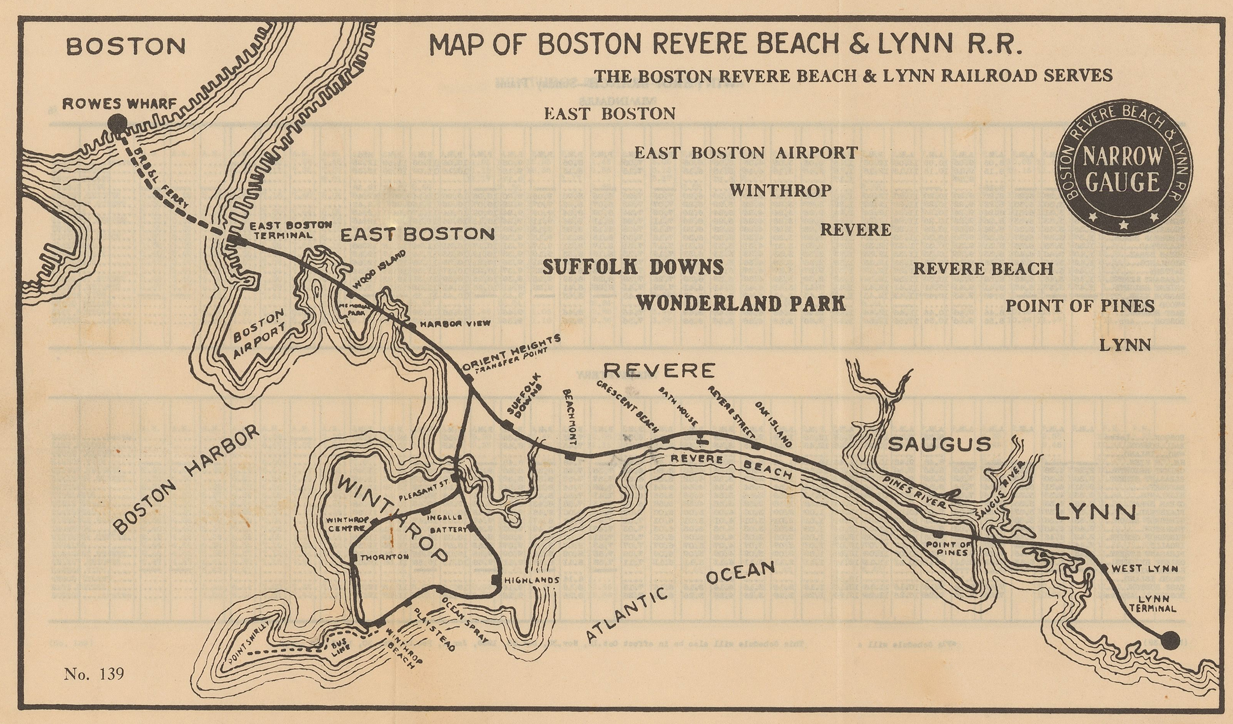
From East Boston to Lynn, the 9.7-miles track included 14 stops and provided frequent service to commuters and day-trippers. A line to Winthrop with nine stops was added in 1891, and spurred development of many of the town’s neighborhoods.
“Summer Sundays, it was a big, big outing to go to Revere Beach for the day with our bundles and picnic. My whole family went: parents, aunt, uncle, and cousins. First the elevated trolley to Rowes Wharf. Next the ferry over to East Boston—the only time I was on a boat as a child! Then the narrow gauge train to the Oak Island stop, where the beach was less crowded. After a day on that beautiful beach, back home we went: train, ferry, trolley.”
Henrietta Dilyock, born 1918
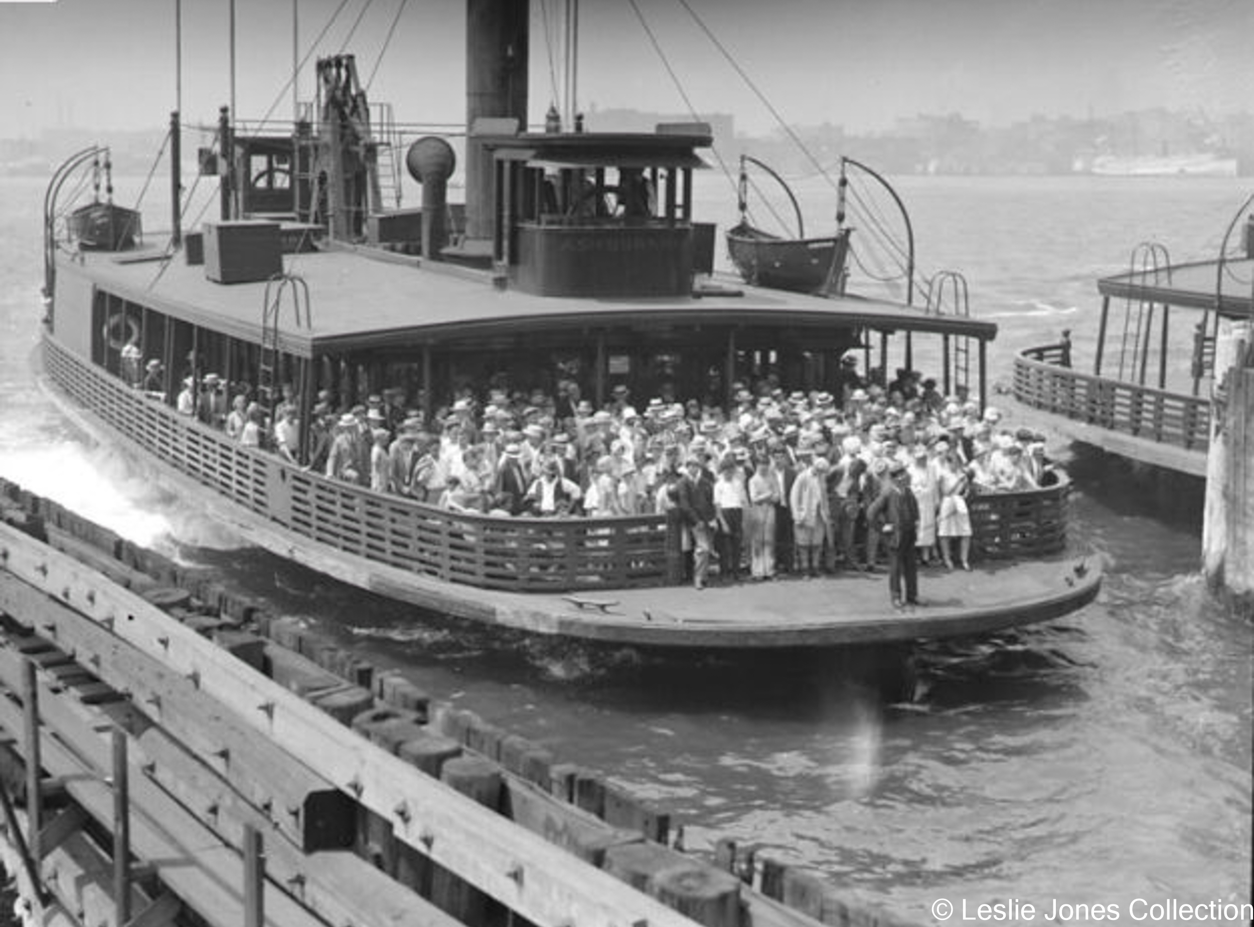
Thousands had access to the narrow gauge train because an elevated trolley, which stopped at North and South station, also had a stop at Rowes Wharf. The cost of the 10-minute ferry ride from there to East Boston was included in the train ticket price.
Ferry Ashburnham in 1923; courtesy of Boston Public Library, Leslie Jones Collection
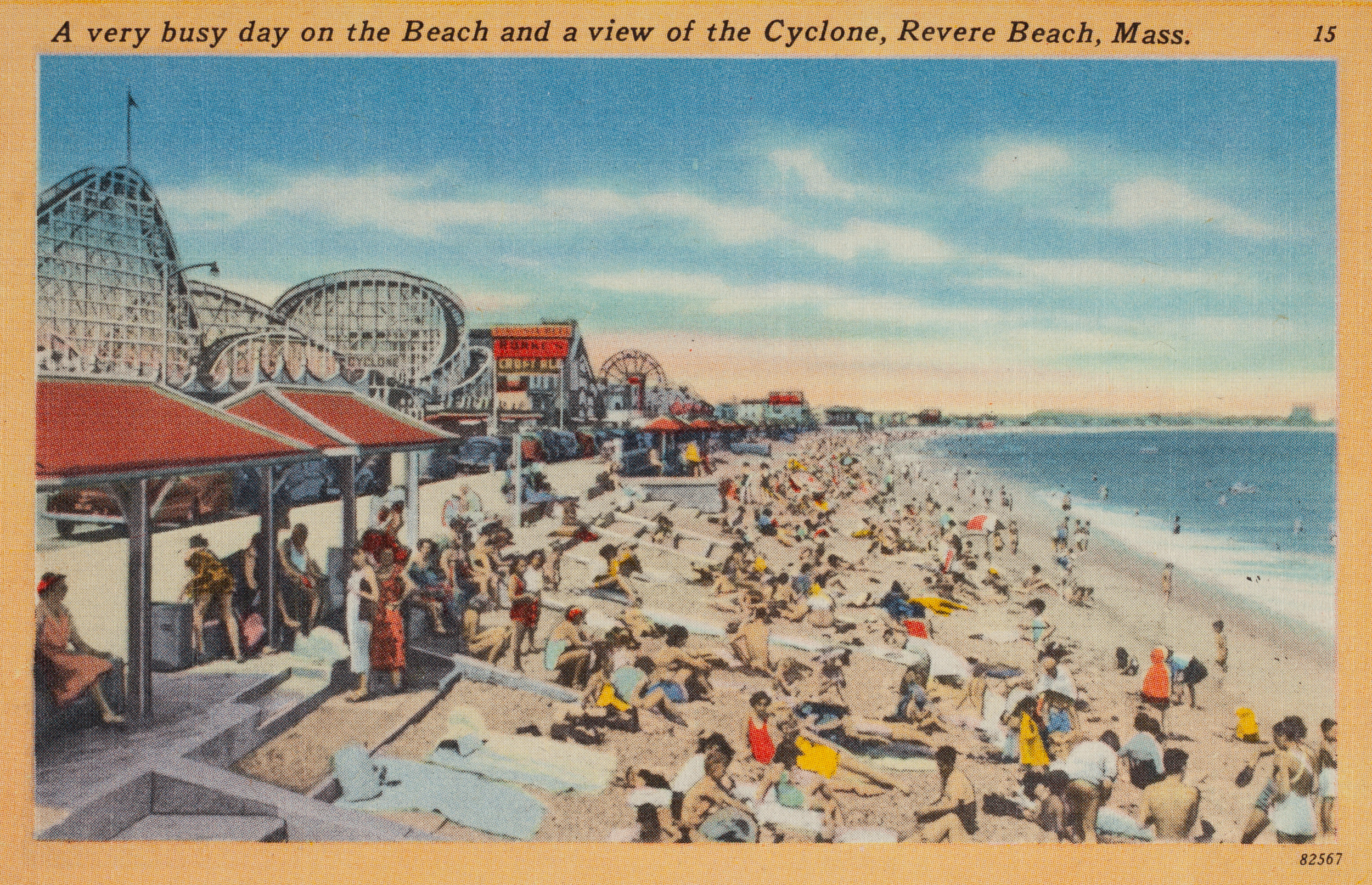
The train’s most popular stop was Revere Beach—the first public beach in the country. The three-mile sandy stretch and nearby Wonderland Park drew enormous crowds that came mostly by the narrow gauge. The track originally ran along the beach itself, but in 1900 was relocated a few blocks inland to make way for Revere Beach Boulevard.
Postcard courtesy of Historic New England
More …
from Stanley, Robert C. with William Lieberman. Narrow Gauge: The Story of the Boston, Revere Beach & Lynn Railroad. Boston Street Railway Association, Inc., 1980.
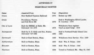
from Stanley, Robert C. with William Lieberman. Narrow Gauge: The Story of the Boston, Revere Beach & Lynn Railroad. Boston Street Railway Association, Inc., 1980.
from Stanley, Robert C. with William Lieberman. Narrow Gauge: The Story of the Boston, Revere Beach & Lynn Railroad. Boston Street Railway Association, Inc., 1980.
Community activists. Colonial law. Political will. New state regulations. The combination created the 43-mile Boston Harborwalk–a public path, stretching from Logan Airport through seven neighborhoods to the Neponset River. In 1978, the Massachusetts Office of Coastal Zone Management (CZM) sought to improve public access to the waterfront. They succeeded by integrating early Colonial laws into new state regulations.
In the decades that followed, community activists, city and state government, and developers of shoreline projects have worked together to ensure the Harborwalk is always constructed along the waterfront. Some sites also provide public amenities–bathrooms, meeting places, kayak launches,
etc. The result is a fabulous path welcoming residents and visitors to our vibrant clean harbor.
Early Colonial laws established public right of access along tidelands to protect citizens’ rights to fish, hunt, and navigate at sea and along the shorefront. These laws go back even further: They stem from Roman law, which was incorporated into English law and brought over to Massachusetts by English
settlers. Then, in the 1640s, Massachusetts Bay Colony passed laws permitting private docks in the intertidal area (between low and high tide) as long as public access was retained. Almost all of Boston’s waterfront is filled land that was once the intertidal area. This, together with the centuries-old legal right of access, served as the underpinnings for the 1978 CZM regulations.
Resources
- Bradlee, Francis B. C. “Boston, Revere Beach & Lynn Railroad,” The Essex Institute Historical Collections, Volume LVII, 1921.
- Burden, Leanne and Lisa Tuite. “The Boston, Revere Beach & Lynn Railroad,” The Boston Globe, February 7, 2014.
- Kyper, Frank. Narrow Gauge to Boston: A Nostalgic Window on the BRB & Lynn RR. South Platte Press, 2010.
- Liljestrand, Robert A. Boston, Revere Beach and Lynn Railroad. Bob’s Photo, 2002.
- Stanley, Robert C. with William Lieberman. Narrow Gauge: The Story of the Boston, Revere Beach & Lynn Railroad. Boston Street Railway Association, Inc., 1980.
- “And This is Good Old Boston”
- Conversation with Henrietta Dilyock, summer 2019
Acknowledgments
- Deep gratitude to the late Robert Stanley, train enthusiast, who shared his knowledge and images so generously.
- Our warm thanks to Henrietta Dilyock for sharing her memories of taking the Narrow Gauge to the beach as a girl.
- And thank you to Todd Gieg, who is building an extraordinary model of the Narrow Gauge, part of which can be seen at the Lynn Museum.