Moving People and Goods
in the Wharf District

The Elevated Atlantic Avenue segment operated from 1901 to 1938. Rowes Wharf station is in the foreground; State Street station to the north.
Courtesy of the Robert Stanley Collection
The construction of Atlantic Avenue along the waterfront in 1870 helped improve Boston’s transportation infrastructure. Two years later, Union Freight Railway tracks were added down the middle, connecting Boston’s north and south rail terminals. Spurs onto wharves and to warehouses facilitated transfer of goods. But the street-level track proved so dangerous that city officials restricted the number of rail cars and the train’s hours of operation.
The Boston Elevated Railway Atlantic Avenue route, installed right above the freight line was less controversial. It helped meet the needs of Boston’s rapidly expanding population. With stations at key wharves, “the El” connected people to harbor ferries as well as steamship lines to destinations like Nantasket Beach, Philadelphia, New York, and Portland, Maine.
For decades, you could hop off a trolley at Rowes Wharf station, cross the harbor to East Boston by ferry, and then board the popular narrow gauge train to Revere Beach. Today, a ferry runs to Hingham, water taxis take you wherever you wish, and vessels can be chartered for cruises around the harbor and beyond.
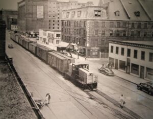
Union Freight Railroad trains continued to rumble along Atlantic Avenue and Commercial Street until March 1970, long after the elevated track was taken down. Its maximum permitted speed 4 m.p.h.
Courtesy of Boston Public Library
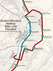
The El’s Atlantic Avenue route was a branch off the Main Line Elevated which ran between Sullivan Square in Charlestown and Forest Hills in Jamaica Plain. It was part of a multi-modal public transporta-tion system that included an extensive street level trolley network.
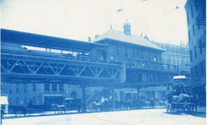
Street-level view of the El’s Rowes Wharf station shortly after it opened in 1901.
Courtesy of City of Boston Archives
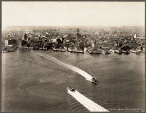
The 1930 aerial shows the ferries coming and going between Rowes Wharf and East Boston, connecting passengers to the Boston, Revere Beach & Lynn narrow gauge railroad.
Courtesy of the Boston Public Library
Sign Location
More …
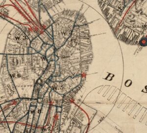
Horse railways had regular routes (shown in blue) including one past Rowes Wharf and then left up tracks laid on Broad Street. The map also shows the new Atlantic Avenue in place to the north. Though Atlantic Avenue shortened several wharves, it provided much better access along the waterfront.
1876 map courtesy of Boston Public Library, Norman B. Leventhal Map and Education Center
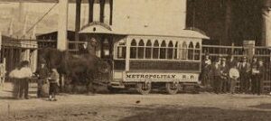
Detail from 1860 photo of a horse-drawn rail trolley.
Photo courtesy of the Boston Athenaeum
Between 1860 and 1930, Boston’s population quadrupled from 177,840 to 781,188. An extensive public transit system was essential to the city’s success.
Folks called it the “Boston El,” “the Elevated,” “the El,” or the BERy.
Early Colonial laws established public right of access along tidelands to protect citizens’ rights to fish, hunt, and navigate at sea and along the shorefront. These laws go back even further: They stem from Roman law, which was incorporated into English law and brought over to Massachusetts by English
settlers. Then, in the 1640s, Massachusetts Bay Colony passed laws permitting private docks in the intertidal area (between low and high tide) as long as public access was retained. Almost all of Boston’s waterfront is filled land that was once the intertidal area. This, together with the centuries-old legal right of access, served as the underpinnings for the 1978 CZM regulations.
Community activists. Colonial law. Political will. New state regulations. The combination created the 43-mile Boston Harborwalk–a public path, stretching from Logan Airport through seven neighborhoods to the Neponset River. In 1978, the Massachusetts Office of Coastal Zone Management (CZM) sought to improve public access to the waterfront. They succeeded by integrating early Colonial laws into new state regulations.
In the decades that followed, community activists, city and state government, and developers of shoreline projects have worked together to ensure the Harborwalk is always constructed along the waterfront. Some sites also provide public amenities–bathrooms, meeting places, kayak launches,
etc. The result is a fabulous path welcoming residents and visitors to our vibrant clean harbor.
Resources
- Beaucher, Steven. Boston in Transit: Mapping the History of Public Transportation in the Hub. WardMaps LLC, 2020.
- “The Wholesale Produce Markets at Boston, Mass.” U.S. Department of Agriculture, Production & Marketing Administration, Washington, DC., June 1950.
- Kyper, Frank. “Boston’s Anonymous Railroad Reached the End of the Track,” in The Railway and Locomotive Historical Society Bulletin, No. 123. October 1970. p. 58-61.
- Kyper, Frank. The Railroad That Came Out at Night. The Stephen Greene Press, 1977.
- “Report of the Commission on Metropolitan Improvements,” 1907.
- “Report of the Directors of the Port of Boston,” year ending November 30, 1914.
- Seasholes, Nancy S. Gaining Ground: A History of Landmaking in Boston. The MIT Press, 2003.
- Seasholes, Nancy S. ed. The Atlas of Boston History, University of Chicago Press, 2019.
- “The Traffic World,”1915.
Acknowledgments
Warm thanks to Steven Beaucher for his expertise.