Italian Service Unit in Boston
in Dorchester

Camp McKay, which occupied part of what is now UMass Boston’s Bayside Lot, was built in just 45 days. Its 93 barracks could house 2,000. It was named for famous clipper ship builder, Donald McKay.
1944 photo courtesy of the National Archives and Records Administration
On September 3, 1943, during World War II, Italy switched sides and joined the Allied powers. This meant that the 51,000 Italian prisoners of war held in the U.S. were no longer “enemy combatants.” They were offered the opportunity to join the newly created Italian Service Unit (ISU). The vast majority did, seizing the chance for paid work and a less restrictive confinement.
Six months later, 1,800 ISU members arrived here at Camp McKay. They immediately began loading supply ships bound for Europe. Italian-Americans in Boston visited the men, bringing traditional food and exchanging news. But by summer, as the war in Europe raged on, veteran groups and some South Boston residents escalated their protests about the Italians’ presence and their right to occasional Sunday passes. Army officials moved ISU members to Fort Andrews on Peddocks Island in Boston Harbor.
After the war ended in 1945, most ISU members returned to Italy. A number married women they’d fallen in love with during visits. Camp McKay was converted into desperately needed housing for returning U.S. veterans and their families.

The Italian Service Unit was part of the U.S. Army Service Forces. ISU members had to swear allegiance to the United States. They wore U.S. Army uniforms with the green ISU insignia on their sleeves.
“[The ISU’s] labor is essential. These men are contributing a great deal to the American war effort!” Brigadier General Calvin Dewitt, commanding officer of the Boston Quartermaster Depot
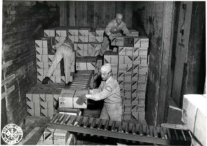
ISU members worked nine-hour days, six days a week loading ships at Boston’s Port of Embarkation—a colossal Army facility where the cruise terminal is today.
National Archives & Records Administration
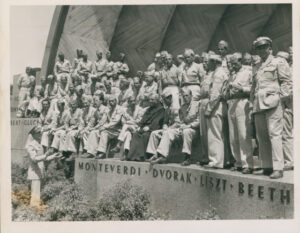
Boston Globe’s article, “Former Italian Prisoners Enjoy Boston’s Hospitality” described how 100 former Italian POWs—with Sunday passes— had attended mass, then sung at the Hatch Shell. Later they “enjoyed an outing in the country.” The front-page story ran alongside one reporting the Allies’ capture of Rome (from the German army). The report likely contributed to mounting local hostility toward the ISU men.
Courtesy of The Boston Globe, June 5, 1944
Sign Location

More …
Resources
- “Army Tells Status of Former Italian Prisoners in Hub.” The Boston Globe, June 12, 1944. https://www.proquest.com/historical-newspapers/army-tells-status-former-italian-prisoners-hub/docview/840219507/se-2.
- Calamandrei Camilla, Prisoners in Paradise: Italian POWs held in America During WW II: A Historical Narrative and Analysis, 2012, https://www.prisonersinparadise.com/
- Conti Giovanni Flavio and Alan R. Perry, “Italian Prisoners of War in the Boston Area during World War II,” The Italian American Review, Vol. 9, No. 2 (Summer 2019), University of Illinois Press, pp. 179–207.
- “Former Italian Prisoners Enjoy Boston’s Hospitality,” The Boston Globe, June 5, 1944.
- “Italian Service Unit of Boston: World War II.” Boston Harbor Islands Blog (Feb. 11, 2021).
- https://www.bostonharborislands.org/blog/italian-service-unit-of-boston-world-war-ii/
- Roessner, Jane. A Decent Place to Live: From Columbia Point to Harbor Point. Northeastern University Press, 2000.
- “Sen. Weeks Reports Only 400 Prisoners Left at Camp McKay.” The Boston Globe, July 22, 1944. https://www.proquest.com/historical-newspapers/sen-weeks-reports-only-400-prisoners-left-at-camp/docview/840009828/se-2.
- War Department. Army Service Forces. Office of the Chief of Transportation. Boston Port ofEmbarkement, 1942-1946. NAIDs: 10525195. National Archives and Records Administration.
Acknowledgments
- Friends of the Boston Harborwalk is deeply grateful to the George B. Henderson Foundation for funding the design, manufacture, and installation of the signs at Columbia Point.
- Thank you to University of Massachusetts Boston Professor Vincent Cannato and author Stephen Puleo for their expert advice.
- Our gratitude to the Perkins School for the Blind Recording Studio and Thomasine Berg for their partnership in creating the audio files.