Harbor of Shame No More
in South Boston

The Deer Island facility can process up to 1.35 billion gallons of wastewater daily. Key features: Tanks that separate solid sludge from wastewater. Secondary treatment that uses microorganisms. Egg-shaped digesters that convert sludge to carbon dioxide, organic solids, water, and methane—which powers the plant.
Courtesy of MWRA
In the 1980s, Boston Harbor was one of the dirtiest in the country, due to centuries of dumping raw and poorly treated sewage and industrial waste into its waters. Pollution threatened irreversible harm to the harbor’s marine habitats, brought slime and foul odors, and closed beaches and shellfish beds.
Today, the Massachusetts Water Resources Authority (MWRA) operates the state-of-the-art Deer Island Wastewater Treatment Plant, which removes pollutants from the wastewater of 43 communities.
After treatment, solid sludge is made into fertilizer pellets–used in gardening and landscaping–while liquid effluent is sent into a 9.5-mile tunnel and discharged into the deep waters of Massachusetts Bay. Ongoing monitoring shows vastly improved conditions in the harbor and no degradation of the bay.
The facility took 15 years, 3.8 billion dollars, and the efforts of thousands of people to plan and build. It transformed Boston Harbor into one of the cleanest in the nation. An environmental treasure that welcomed people to its waters and shores for thousands of years can do so again.
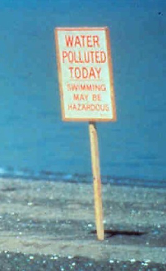
Signs like this one often disappointed beachgoers, especially after heavy rainstorms overwhelmed the former treatment plant’s capacity.
Courtesy of MWRA
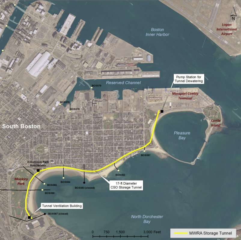
A storage tunnel under South Boston beaches virtually eliminates the sewer system discharges into the harbor that occurred there after heavy rains. Now the overflow–a combination of sewage and stormwater–is held in the tunnel, to be pumped to the treatment plant when capacity allows
Courtesy of MWRA
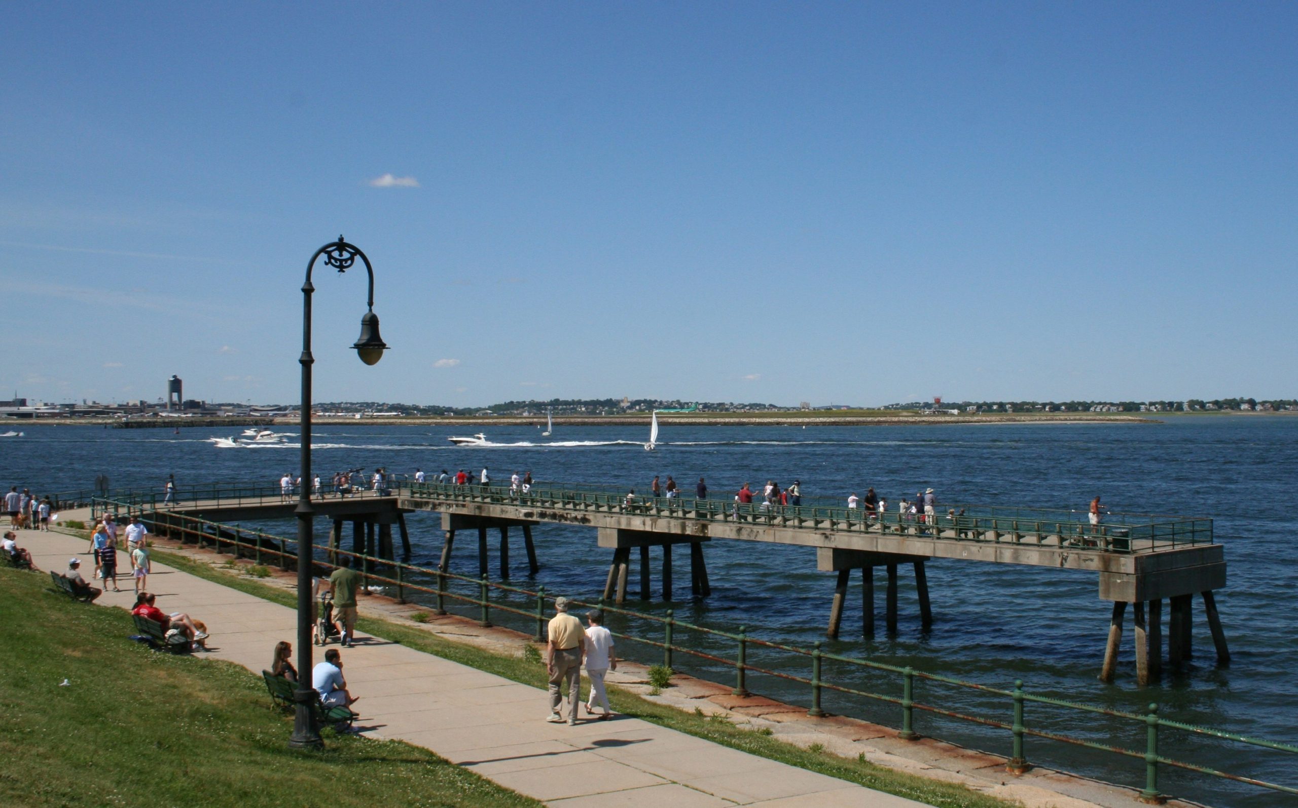
Fishing enthusiasts flock to McCorkle Pier to catch striped bass, bluefish, winter flounder and cunner–depending on season and tide.
Photo by Robert Gillis / GillisPhotos.com
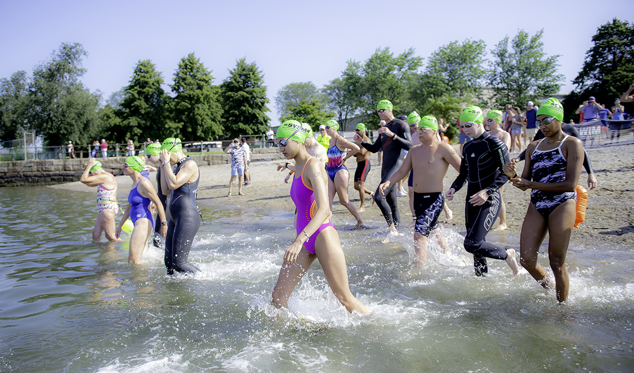
Boston beaches are swimmable again, and Pleasure Bay is one of the cleanest. In August 2021, Swim Across America Boston held their open water swim here to benefit cancer research.
Courtesy of John Deputy, Dana-Farber Cancer Institute
Sign Location

More …
Resources
- Acitelli, Tom. “Deer Island Treatment Plant: 9 fun facts about the Boston area’s sewage hub.” Curbed Boston, May 17, 2017. https://boston.curbed.com/2017/5/17/15653952/deer-island-treatment-plant-boston Accessed Dec 11, 2021.
- Boston Harbor Now. Boston Harbor: 50 Years of Transformation. https://youtu.be/0m22g4qbm2Q Accessed Dec 11, 2021.
- Boston celebrates Clean Water Act anniversary
https://edition.pagesuite.com/popovers/dynamic_article_ popover.aspx?artguid=9b43f590- 12a6-4dbb-af51-c143f9fc6bd4 - Colarusso, Phil. “Love that Dirty Water?” The EPA Blog, April 29, 2013. https://blog.epa.gov/2013/04/29/love-that-dirty-water/ Accessed 4 Dec 2021.
- Conservation Law Foundation. The Boston Harbor Clean-up Reaches a New Milestone. https://youtu.be/rgp3GMUBM3o Accessed Dec 11, 2021.
- Daley, Beth. “A clean new era for Boston Harbor.” The Boston Globe, June 23,2011. http://archive.boston.com/lifestyle/green/articles/2011/06/23/sewage_tank_will_all_but_eliminate_beach_closures_in_boston/ Accessed Dec 11, 2021.
- DeMarco, Peter. “In the Sugar Bowl, they find, life is sweet.” Boston Sunday Globe City Weekly, October 23, 2005, p 5.
- Doolin, Eric Jay. Political Waters: The long, Dirty, Contentious, Incredibly Expensive but Eventually Triumphant History of Boston Harbor – A Unique Environmental Success Story. University of Massachusett Press, 2004.
- “Lt John J. Mccorkle Fishing Pier Fishing Spot.” MA Fish Finder, August 26, 2016. https://www.mafishfinder.com/lt-john-j-mccorkle-fishing-pier-26545-location.html Accessed Dec 11, 2021.
- Massachusetts Water Resources Authority. Boston Harbor Fish and Shellfish https://www.mwra.com/harbor/html/harbor_fish.htm Accessed Dec 11, 2021.
- Massachusetts Water Resources Authority. The Boston Harbor Project: An Environmental Success Story, Dec 16, 2014. https://www.mwra.com/01news/2008/bhpenvironentalsuccess/bhpenvsuccess.htm Accessed Dec 11, 2021.
- Massachusetts Water Resources Authority. The Deer Island Sewage Treatment Plant, Sep 2, 2009. https://www.mwra.com/03sewer/html/sewditp.htm Accessed Dec 4, 2021.
- Massachusetts Water Resources Authority. How the Sewer System Works, February 12, 2012 https://www.mwra.com/03sewer/html/sewhow.htm Accessed Dec 11, 2021.
- Massachusetts Water Resources Authority. MWRA At 30, July 2015. https://www.mwra.com/publications/presentations/2017/2017-07-MWRA-at-30.pdf Accessed Dec 11, 2021.
- Massachusetts Water Resources Authority. MWRA Completes overflow tunnel in South Boston, June 23, 2011. https://www.mwra.com/01news/2011/062311-cso-sb.html Accessed Dec 11, 2021.
- Massachusetts Water Resources Authority. The State of Boston Harbor: Mapping the Harbor’s Recovery, December 2002. https://www.mwra.com/harbor/enquad/pdf/2002-09.pdf Accessed Dec 11, 2021.
- Massachusetts Water Resources Authority. Winter Flounder. https://www.mwra.com/harbor/html/winterflounder.htm Accessed Dec 11, 2021.
- Moore, Michael. “Tumor-free flounder are just 1 dividend from the cleanup of Boston Harbor.” The Conversation, January 10, 2019. https://theconversation.com/tumor-free-flounder-are-just-1-dividend-from-the-cleanup-of-boston-harbor-109217 Accessed Dec 11, 2021.
- United States Environmental Protection Agency. Combined Sewer Overflow Technology Fact Sheet: Retention Basins. September 1999. https://www3.epa.gov/npdes/pubs/csoretba.pdf Accessed Dec 11, 2021.
- United States Environmental Protection Agency. Combined Sewer Overflow Management Fact Sheet Sewer Separation. September 1999. https://www3.epa.gov/npdes/pubs/sepa.pdf Accessed Dec 11, 2021.
- Valencia, Milton J. “After 30 years, court marks Boston harbor cleanup.” The Boston Globe, August 6, 2016. https://www.bostonglobe.com/metro/2016/08/06/three-decades-later-court-celebrates-end-boston-harbor-cleanup-era/EFKyY9F63azlbFU5BBR1fK/story.html Accessed Dec 11, 2021.
- “Water Quality Report Card.” Save the Harbor Save the Bay, July 4, 2021. https://www.savetheharbor.org/reportcard Accessed Dec 11, 2021.
- Werme Christine, et. al. 2020 Outfall Monitoring Overview. Massachusetts Water Resources Authority. Report, November,10 2021. https://www.mwra.com/harbor/enquad/pdf/omo.pdf Accessed Dec 11, 2021.
- Yannone, Tessa. “The Best Spots for Urban Fishing in Boston.” Boston Magazine. https://www.bostonmagazine.com/health/urban-fishing-in-boston/ Accessed Dec 11, 2021.
- Environmental lawyer led effort to clean up Boston Harbor
Acknowledgments
- This sign is made possible with funding from a Boston Community Preservation Fund grant.
- Many thanks to Ria Convery of the Massachusetts Water Resources Authority for her invaluable help in the creation of this sign.
- Our gratitude to the Perkins School for the Blind Recording Studio and Thomasine Berg for their partnership in creating the audio files.