Freedom by Sea
in South Boston

Drake’s Wharf once stood on the opposite side of Fort Point Channel from here. It was one of several places along Boston’s waterfront where self-emancipated individuals came ashore with the help of Boston’s abolitionists.
Bearse, Austin. Reminiscences of Fugitive-Slave Days in Boston, 1880
“It cannot be that I shall live and die a slave. I will take to the water. This very bay shall yet bear me into freedom,” wrote Frederick Douglass of his hope to escape slavery by ship.
Escape was fraught with danger even for those making the journey to freedom by sea. Thousands took advantage of their work on the waterfront, proximity to waterways, boating skills, or contacts to escape bondage on a northbound ship. Some encountered sympathetic captains or crew members; others paid for their passage. Many hid on a vessel, unbeknownst to captain or crew. Boston and New Bedford with strong communities of Black activists and Underground Railroad networks were favored destinations.
Southern states passed Negro Seamen Acts—jailing Black mariners while their ships were docked to prevent contact with the enslaved. Departing vessels were searched. Even after reaching Boston Harbor, some freedom seekers were detained on ships and then returned South. Nevertheless, many courageous, resourceful runaways succeeded—in one case by swimming to safety on one of the Boston Harbor islands.
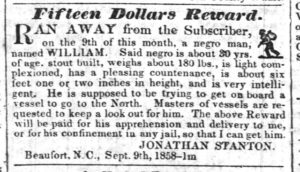
The Library of Congress estimates that more than 200,000 runaway slave notices were placed in colonial and U.S. newspapers between 1730 and 1865. Many of these ads included warnings for ship captains not to aid freedom seekers.
New Era and Commercial Advertiser, September 14, 1858

“‘You had better come out! I am going to smoke the vessel!’ I heard him call, but my mind was liberty or death.” Elisabeth [Betsy] Blakeley lay hidden below deck when she heard her enslaver board the ship and shout. She withstood three fumigations—a mix of sulphur and tobacco—before her enslaver gave up, and the ship sailed to Boston.
Recounted by Wendell Phillips in Reminiscences of Fugitive-Slave Days in Boston, by Austin Bearse, 1880
“I slipped myself between two bales of cotton, with the deck above me… and just then a bale was placed at the mouth of my crevice and shut me in a space about 4 ft by 3 ft. I then heard them gradually filling up the hold; and at last the hatch was placed on, and I was left in total darkness.”
John Andrew Jackson had to reveal himself within days, and the captain was determined to put him off as soon as he encountered a south bound vessel. It didn’t happen. And on Feb 10, 1847, when the ship docked in Boston, Jackson stepped ashore.
[
Jackson, John Andrew. The Experience of a Slave in South Carolina,1862
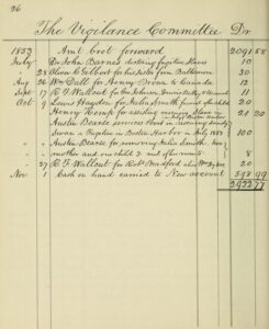
The third Boston Vigilance Committee formed in 1850 “to assist fugitive slaves.” In the decade that followed, dedicated abolitionists (Black and white) aided almost 450 fugitives, paying for their rescue, room and board, clothing, and for some, tickets to Canada.
Account Book of Francis Jackson, treasurer of The Vigilance Committee of Boston
Sign Location

More …
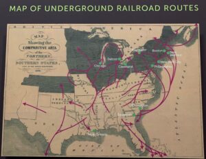
Note the escape routes by sea. They were, in fact, far more extensive than recognized at the time.
Map printed in Harper’s Weekly, February 1861
Before the Vigilance Committee was established, Boston’s Black community formed the Freedom Association in 1842. This association provided fugitives with food, clothing, shelter, and any other aid necessary to assure their freedom. In addition, there were many informal efforts by people of color to assist those in need.
source: Black Bostonians: Family Life and Community Struggle in the Antebellum North by James Oliver Horton and Lois E. Horton, p. 108.
“On the 4th of December, 1858, I [Philip Smith] secreted myself on board the brig William Purington of Boston, then lying at the wharf in Wilmington, N.C. Three days afterwards, the brig sailed for Boston…. [When discovered] the captain swore terrible oaths at me…. On the evening of December 26, we arrived at the outer harbor of Boston. [The vessel ran aground.] At daylight, I swam to Lovell’s Island, a distance of about 200 feet…. I then travelled over to the other side of the island, entirely out of sight of the brig. I kept constantly walking to and fro, to keep from freezing, for about two hours, when I spied a small sail boat, and held up my pocket handkerchief as a signal of distress…. They took me up to the city, and landed me upon Commercial Wharf.”
[credit] Quoted by William Lloyd Garrison in The Liberator, March 4, 1859Community activists. Colonial law. Political will. New state regulations. The combination created the 43-mile Boston Harborwalk–a public path, stretching from Logan Airport through seven neighborhoods to the Neponset River. In 1978, the Massachusetts Office of Coastal Zone Management (CZM) sought to improve public access to the waterfront. They succeeded by integrating early Colonial laws into new state regulations.
In the decades that followed, community activists, city and state government, and developers of shoreline projects have worked together to ensure the Harborwalk is always constructed along the waterfront. Some sites also provide public amenities–bathrooms, meeting places, kayak launches,
etc. The result is a fabulous path welcoming residents and visitors to our vibrant clean harbor.
Early Colonial laws established public right of access along tidelands to protect citizens’ rights to fish, hunt, and navigate at sea and along the shorefront. These laws go back even further: They stem from Roman law, which was incorporated into English law and brought over to Massachusetts by English
settlers. Then, in the 1640s, Massachusetts Bay Colony passed laws permitting private docks in the intertidal area (between low and high tide) as long as public access was retained. Almost all of Boston’s waterfront is filled land that was once the intertidal area. This, together with the centuries-old legal right of access, served as the underpinnings for the 1978 CZM regulations.
Resources
- Account Book of Francis Jackson, treasurer of the Vigilance Committee of Boston
- Bardes, John. “Sailing While Black”
- Bearse, Austin. Reminiscences of Fugitive-Slave Law Days in Boston, Printed by W. Richardson, 1880.
- Cecelski, David S., “The Shores of Freedom: The Maritime Underground Railroad in North Carolina, 1800-1861,” The North Carolina Historical Review, Vol. 71, No. 2 (APRIL 1994), pp. 174-206
- Maritime Underground Railroad in NC.pdf
- Digital Library of American Slavery, North Carolina Runaway Slave Notices 1750-1865 dlas.uncg.edu
- “Escape of a Fugitive Slave from a Vessel in Boston Harbor,” The Liberator. 31 December 1858.
- Horton, James Oliver and Lois E. Horton. Black Bostonians: Family Life and Community Struggle in the Antebellum North. Holmes & Meier, 1999.
- Jackson, John Andrew. Experiences of a Slave in South Carolina, 1862. Includes his escape by ship to Boston
- Rediker, Marcus. Freedom Ship: The Uncharted History of Escaping Slavery by Sea. Viking, 2025.
- Walker, Timothy D. Ed. Sailing to Freedom, Maritime Dimensions of the Underground Railroad. University of Massachusetts Press, 2021.
- https://www.nps.gov/articles/maritime-underground-railroad-in-boston.htm
- https://app.freedomonthemove.org/search?limit=12&page=9&q=vessel for runaway slave ads noting vessels
- https://guides.loc.gov/chronicling-america-fugitive-slave-ads
Acknowledgments
Warm thanks to NPS historian Shawn Quigley and University of Massachusetts, Dartmouth, professor of history Timothy Walker for their guidance and expertise.