A Climate Resilient Park
in the North End

The red line shows areas of the park designed to withstand sea level rise, with park features built higher to protect them and ensure longevity.
Courtesy of Weston & Sampson
Climate Ready Boston is the city’s program to prepare for rising seas, stronger coastal storms, hotter days, and heavier rainfall due to climate change. One strategy is to redesign waterfront parks–like this one–so they can be enjoyed by residents and protect neighborhoods from these changes.
The 2020 plan for this park was the first to put in place Boston’s new climate resiliency standards. To limit the impact of coastal storms, the Harborwalk, built above the existing seawall, can handle occasional flooding. A second seawall protects park amenities and provides seating with waterfront views. Also play areas have been raised high enough to protect them, as well as nearby homes and businesses, from most severe floods until about 2050.
To limit the impact of heavier rainfall, an upgraded stormwater drainage system was installed. Sloped walking paths direct water away from the neighborhood, across the park, and into the harbor. And native plantings near the water’s edge tolerate salt and standing water. These improvements ensure the park can serve its dual roles for decades to come.
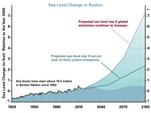
Scientists agree global warming threatens our planet. If we reduce carbon emissions, however, we can limit sea-level rise by the year 2100 to two feet or less.
Created by Sheila J. Frazier, with data from the National Oceanic and Atmospheric Administration (NOAA)
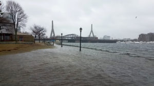
Before the park was renovated, two storms in March 2018 coincided with very high “King Tides,” causing significant flooding along Boston’s waterfront, including the northwest section of this park. The city’s initiatives to address climate change took on new urgency.
Courtesy of Weston & Sampson
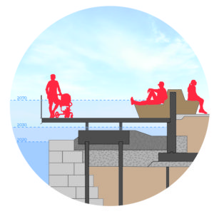
Sea water can rise and fall beneath the cantilevered Harborwalk.
Courtesy of Weston & Sampson
Sign Location

More …
Resources
Acknowledgments
- Our gratitude to the Perkins School for the Blind and David W. Cook for their partnership in creating the audio files.
- Thank you to the Boston Marine Society for funding the Spanish and Italian translations as well as the recording of this sign.