A Civil Engineering Feat
in Charlestown
(awaiting installation)
More than 700 feet long, Dry Dock #2 could accommodate the largest ships of the era. A vessel would enter when the dock was filled with water. Once it was secured in place and the caisson closed the entrance, the water was pumped out, giving men access to the hull to make all necessary repairs.
Photo by Walcott Cutler, courtesy of the Boston Public Library
This water-filled area in front of you was once the largest dry dock in the country. Completed in 1905, Dry Dock #2 was a key feature of the U.S. Navy’s modernization plan begun in the late 1800s. Hundreds of vessels were repaired or constructed here, often two or more at a time.
The Pump House behind you was an integral part of this engineering success. It served both Dry Dock 2 and Dry Dock 1 nearby, through a duct that ran under the dry dock 60 feet below ground. Its massive electrical pumps could fill Dry Dock #2 in one hour and drain it in two.
A hollow, steel barrier called a caisson—102 feet long, 36 feet deep—floated along Pier 3 when not in use. After a vessel entered the dry dock, the caisson was fitted into grooves at the entrance and pumped full of water so it would sink, closing the dry dock. The grooves and exterior water pressure kept the caisson in place so its water could then be pumped out.
Dry Dock #2 served ships until 1974 when the navy yard closed.
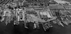
This 1932 photo shows Charlestown Navy Yard Dry Dock 1 empty and Dry Dock 2 with a vessel undergoing repairs.
US National Archives and Records Administration
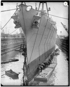
USS Northampton in Dry Dock #2, 1930
Courtesy of Boston Public Library, Leslie Jones Collection
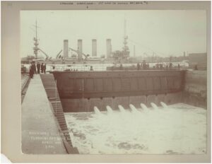
Outlets in the caisson would also be used to fill the dry dock when a ship was ready to leave. Behind the caisson waits the USS Maryland—the first ship to enter the dock.
August 1905 photo courtesy of the National Park Service
Sign Location

More …
Resources
- Carlson, Stephen P., Charlestown Navy Yard Historic Resource Study. Vol 1 – 3. Boston National Historical Park, 2010.
- Charlestown Navy Yard. National Park Handbook. Produced by the Division of Publications National Park Service, 1995.
- “Interesting Accessories to New Drydock at Charlestown Navy Yard,” Boston Globe, November 14, 1904.
- “Drydock’s First Test Next Monday,” Boston Globe, March 25, 1905.
- “Charlestown Drydock Now Ready for Formal Acceptance,” Boston Globe, July 26, 1905.
- “USS Maryland Floated Into New Drydock,” Boston Globe, August 12, 1905.
- “Boston Serves the World’s Greatest Ships,” First National Bank of Boston Advertisement, Boston Globe, June 25, 1935.
Acknowledgments
Warm thanks for NPS historian Steven Carlson for his expertise.