Protecting the Fleet
in Charlestown

Painting crew applies a fresh coat to the USS Raleigh in a Charlestown Navy Yard dry dock.
1929 photo courtesy of the Boston Public Library, Leslie Jones Collection
The Paint Shop behind you was built in 1906. It was a secure facility for storing and mixing marine paints. It also housed offices, break rooms, and restrooms for the painting staff. The Paint Shop was strategically located between Drydock 1 and 2 where many ships were painted. Smaller vessels, under 2,000 tons, were often painted after being hauled out on the Marine Railway located behind the Paint Shop. Completed in 1919, its remnants are visible today.
Before radar was invented, paint also played a strategic role. During World War I, the threat of German U-boats targeting Allied supply lines led the U.S. Navy to adopt a British camouflage technique. Dubbed “dazzle-painting,” thousands of ship hulls were painted in a riot of contrasting colors, jagged lines, and abstract geometric patterns, making it difficult for enemy submarines to determine a ship’s size, speed, and direction. Its effectiveness in protecting the fleet is hard to assess, but the U.S. Navy reported that more than 18,000 ships crossed the Atlantic safely while painted in these striking patterns.
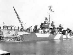
While docked at the Charlestown Navy Yard in 1944, the USS Norman Scott was among the ships painted not just with a standard protective coating but with the “dazzle” technique. The patterns created optical illusions designed to confuse enemy U-boats trying to track their movements. Torpedoes missed their targets.
Photo courtesy of the National Park Service
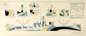
In 1918 the Navy established a department called the Camouflage Section, comprised of artists and scientists, to further anti-submarine camouflage for Navy warships. Dazzle-painting was widely used again during World War II, not only for ships but for planes as well.
Image courtesy of the Naval History and Heritage Command
“It was not until she was within half a mile that I could make out she was one ship [not several] steering a course at right angles, crossing from starboard to port. The dark painted stripes on her after part made her stern appear her bow, and a broad cut of green paint amidships looks like a patch of water. The weather was bright and visibility good; this was the best camouflage I have ever seen.”
U-boat captain, quoted in Camouflage by Tim Newark
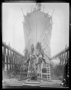
1930 photo of the painting crew with the USS Ericsson on the Marine Railway. Smaller naval vessels from tugboats to submarines were brought ashore on a wood cradle. Once the vessel was securely in position, the cradle would be pulled out of the water up the railroad tracks by a winching system. The navy yard marine railway was in use for almost 50 years.
Photo courtesy of the Boston Public Library, Leslie Jones Collection
Sign Location

More …
Resources
- Behrens, Roy R. “Disruption versus Dazzle: Prevalent Misunderstandings About World War 1 Ship Camouflage,” 2018. http://www.bobolinkbooks.com/Camoupedia/DazzleCamouflage/dazzle.html
- Carlson, Stephen P., Charlestown Navy Yard Historic Resource Study. Vol 1 – 3. Boston National Historical Park, 2010.
- Dazzle Print Collection at Rhode Island School of Design https://digitalcommons.risd.edu/dazzleprints/
- “Dazzle Paint Ship Camouflage Designs” Naval History and Heritage Commandhttps://www.history.navy.mil/our-collections/art/exhibits/conflicts-and-operations/wwi/dazzle-paint-ship-camouflage-designs-.html
- International Spy Museum exhibit on Camouflage and Espionage https://www.spymuseum.org/exhibition-experiences/
- “Razzle Dazzle the Art and Science of Ship Camouflage in Word War 1”https://www.history.navy.mil/content/dam/nhhc/browse-by-topic/War%20and%20Conflict/world-war-i/RDpanels_small.pdf
- Newark, Tim, Camouflage. Thames and Hudson / Imperial War Museum, 2007, p. 74.
- “Short History of US Naval Camouflage in World War II” https://www.usndazzle.com/Camo.php
Acknowledgments
Warm thanks to Roy Behrens for his advice and sharing so much information about dazzle-painting.
We are deeply grateful for NPS historian Steve Carlson’s careful review of all our Charlestown Navy Yard signs.
Reviewed by Steve Carlson, NPS historian Our gratitude to the Perkins School for the Blind and Thomasine Berg for their partnership in creating the audio files.