Native Places, Native Lives
in Dorchester

An Indigenous artist envisions the world before Europeans. The nearby islands, with their varied terrain, provide a cornucopia of food. The Neponset River enters at right, while the Blue Hills rise in the distance.
Artwork by Norma Randi Marshall, Wabanaki artist
The people of the Massachusett Tribe have been part of this place since the lands and the rivers as we know them formed. They interacted with all aspects of the environment as equal and integral members of an interdependent community with reciprocal responsibilities.
Traditional life followed seasonal rhythms. In spring small groups spent time on the coast and islands tending crops, harvesting seafood, and processing foods for winter. In fall they migrated inland and settled in larger communities along waterways, sharing food, teachings, and production of needed materials such as clothing, baskets, and tools. Settlement locations changed periodically to avoid overuse. All members of the community, including children, contributed their talents.
This way of life was upended when English colonists arrived, claiming the land as their own. Yet the Massachusett people are still here. Then as now tribal leadership is shared broadly, with leadership roles held by both men and women and decisions made by consensus. The Massachusett people continue to honor their ancestors and teach their traditions.
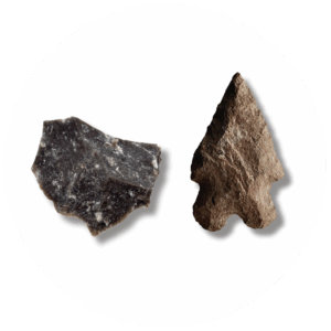
The Blue Hills are a rich source of stone ideal for toolmaking, particularly rhyolite at left. Skilled stoneworkers quarried raw materials there and at long distances to craft tools. This small stone point from Boston’s Long Island is made of rhyolite found only in Attleboro. At 8,000-10,000 years old, its currently Boston’s oldest stone tool.
Photographs courtesy of Boston Archaeology Program
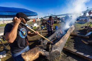
The Massachusett traveled within Boston Harbor and along inland waterways in mishoons, dugout canoes created by controlled burning of felled trees. In 2022, their descendants revived the long-practiced tradition.
Photograph courtesy of Jesse Costa, WBUR
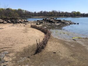
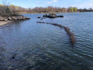
Massachusett people developed an ingenious technique of fishing by using tides to corral fish behind fence-like structures called fishweirs. A vast network of weirs covered the Back Bay tidal estuary, for example. Today the Massachusett recreate fishweirs as an act of cultural reclamation.
Photographs courtesy of Thomas Green
Sign Location

More …
Resources
- Bagley. Joseph. “The Blue Hills: Archaeological Wonder of Epic Proportions.” Friends of the Blue Hills, October 15, 2014. https://friendsofthebluehills.org/keynote/ Accessed February 20, 2025.
- Bagley. Joseph. A History of Boston in 50 Artifacts. University Press of New England, 2016.
- “Home.” Ancient Fishweir Project, Last modified 2020. https://www.fishweir.org/ Accessed February 20, 2025.
- Kanouse, Sarah. “Native Spaces.” https://readysubjects.org/portfolio/portfolio/native-spaces/ Accessed February 20, 2025.
- Kanouse, Sarah and Elizabeth Solomon. Native Spaces. https://findnative.space/ Accessed February 20, 2025.
- Kimmerer, Robin Wall. Braiding Sweetgrass: Indigenous Wisdom, Scientific Knowledge and the Teachings of Plants. Milkwood Editions, 2015.
- Norma Randi Marshall’s art at https://www.normarandi.com/
- “Massachusett Tribe,” Facebook. https://www.facebook.com/p/Massachusett-Tribe-100064599162539/ February 20, 2025.
- “The Massachusett Tribe at Ponkapoag.” The Massachusett Tribe at Ponkapoag Accessed February 20, 2025.
- McHugh, Michael. “‘Native Spaces’ public art project explores Indigenous history, presence in Salem.” The Salem News, October 16, 2024. https://www.salemnews.com/news/native-spaces-public-art-project-explores-indigenous-history-presence-in-salem/article_18bea85c-899f-11ef-94ac-3bb93ad262cc.html Accessed April 21, 2025.
- New England Aquarium. “The Indigenous History of Boston Harbor: A Q&A with Thomas Green of the Massachusett Tribe.” https://www.neaq.org/the-indigenous-history-of-boston-harbor/ Accessed February 20, 2025.
- Russell, Howard S. Indian New England before the Mayflower. Hanover (N.H.): University Press of New England, 1980.
- Seasholes, Nancy S., edt. Atlas of Boston History. University of Chicago Press 2019.
- Young, Lance (Eagle Wolf). “We Are the Land: The Power of Place in Indigenous Life.” Partnership of Historic Bostons and Boston Public Library, September 14, 2022. https://youtu.be/uDFhWZ2f3L4?si=1Wv47BN6FHV2ay91 Accessed March 25, 2025.
Acknowledgments
- Friends of the Boston Harborwalk is deeply grateful to the George B. Henderson Foundation for funding the design, manufacture and installation of the signs at Columbia Point.
- Our gratitude to the Perkins School for the Blind and Thomasine Berg for their partnership in creating the audio files.
- Our thanks to Elizabeth Solomon and fellow members of the Massachusett Tribal Council for their guidance in creating this sign.